Much warmer than average weather coming, rain returns to the west (+4 Maps)
8/08/2018 2:14am

> From the WeatherWatch archives
A front is bringing rain to western New Zealand and will move over the North Island later today and overnight. The peak of heavy rain and strong winds will be later today and overnight in the North Island. Winds won’t be too strong.
Hourly rainfall rates may be quite heavy though for some, with 20-30mm/hr locally possible and could lead to very localised surface flooding.
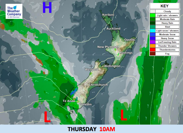
The front will clear off the North Island early on Thursday morning and sunshine may return during the day from Christchurch right up to Auckland. However, another front will bring rain to most West Coast areas with snow over the high mountains across Southland, Westland and Otago.
As this next front moves eastward, it will likely gradually weaken and a high pressure system in the Tasman Sea will prevail over New Zealand bringing a settled end to the week and start to the weekend. Most major cities have a great weekend on the way.
Once again temperatures will be much warmer than average throughout this week. Rain clouds may lower temperatures in some areas for a time (but only back to average) however most people will find daytime temperatures on the sunny days to be quite comfortable. Coolest days look to be Thursday for some southerners and Friday for some central and northern areas.


– WeatherWatch.co.nz
Comments
Before you add a new comment, take note this story was published on 8 Aug 2018.
Latest Video

NZ VIDEO: Severe weather going into the weekend. Next week: Westerlies continue
Heavy rain and northerly gales are moving across NZ going into the weekend as a large low from the Tasman…
Related Articles
NZ VIDEO: Severe weather going into the weekend. Next week: Westerlies continue
Heavy rain and northerly gales are moving across NZ going into the weekend as a large low from the Tasman…

VIDEO: Low pressure, cold fronts, main feature next two weeks
There are several low pressure zones and cold fronts coming into NZ, with westerly driven weather dominating our weather pattern…

VIDEO: Burst of wind and rain for NZ as low pressure dominates
Air pressure around New Zealand will continue to drop in the days ahead as low pressure systems affect our weather…


Add new comment