
> From the WeatherWatch archives
A cold front pushes over the North Island on Monday meanwhile southerlies spread northwards along the South Islands east coast bringing in some wet weather after a dry start.
Mostly cloudy with showers for the western North Island, a period of rain around midday as northwesterlies change westerly then easing back to showers. The Bay Of Plenty is mainly dry then expect a period of afternoon showers before drying out again in the evening. Mainly dry in the east with some high cloud, northwesterlies tend westerly in the afternoon, late afternoon or evening southerlies move into Wairarapa with showers.
Rain with heavy falls for the West Coast of the South Island, easing to showers in the afternoon as southwesterlies freshen. Drying out overnight although showers may still hang about Buller through till Tuesday morning. Scattered rain about Nelson easing to the odd shower in the afternoon, drying out in the evening as westerlies tend southwest.
Spost of rain for Marlborough, some afternoon sun for a time then late afternoon or evening southerlies bring cloud and further showers, perhaps some rain for southern Marlborough. A dry morning for Canterbury then southerlies freshen during the morning with showers developing by afternoon, rain for inland areas by evening with snow to 500m then clearing overnight. South to southwesterly winds freshen about Southland and Otago in the morning bringing some rain, small hail possible and snow lowering to 400m. Conditions clearing up overnight.
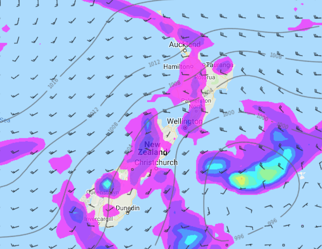
Image: Monday 26th August 2019 3:00pm MSLP / rain map – weathermap.co.nz
WeatherWatch.co.nz
Latest Video
Your NZ forecast through to King’s Birthday Monday
High pressure continues to control NZ’s weather but a change to wet weather and low pressure is expected during the…
Related Articles
Your NZ forecast through to King’s Birthday Monday
High pressure continues to control NZ’s weather but a change to wet weather and low pressure is expected during the…
A few showers, but still a lot of high pressure
Showers continue in parts of NZ going into the weekend and through next week, we track them for you –…
High pressure still in charge, but a few changes in the mix
High pressure continues to control much of New Zealand’s weather although there will be some wind and temperature changes in…

