
> From the WeatherWatch archives
NASA has released a stunning panoramic image of the Martian landscape which it hailed as the “next best thing to being there”.
The image was compiled from 817 images taken between December 21, 2011, and May 8, 2012, while Mars rover Opportunity was stationed on an outcrop informally named Greeley Haven, on a segment of the rim of the ancient Endeavour Crater.
The scene, recorded from a mast-mounted colour camera on top of Opportunity, shows the rover’s own solar arrays and deck in the foreground, and fresh track marks from the rover’s exploration.
“The view provides rich geologic context for the detailed chemical and mineral work that the team did at Greeley Haven over the rover’s fifth Martian winter, as well as a spectacularly detailed view of the largest impact crater that we’ve driven to yet with either rover over the course of the mission,” said Jim Bell of Arizona State University, Tempe, Pancam lead scientist.
The crater spans 22 kilometres in diameter.
North is at the centre of the image, while south is at both ends.
The colours of the image has been altered to emphasise differences between materials in the scene, Nasa explained.
The release of the image comes shortly after Opportunity completed its 3000th Martian day the red planet on July 2.
Opportunity and its twin, Spirit, landed on Mars in January, 2004 for missions originally planned to last for three months.
Nasa’s next-generation Mars rover, Curiosity, is on course for landing on Mars next month.

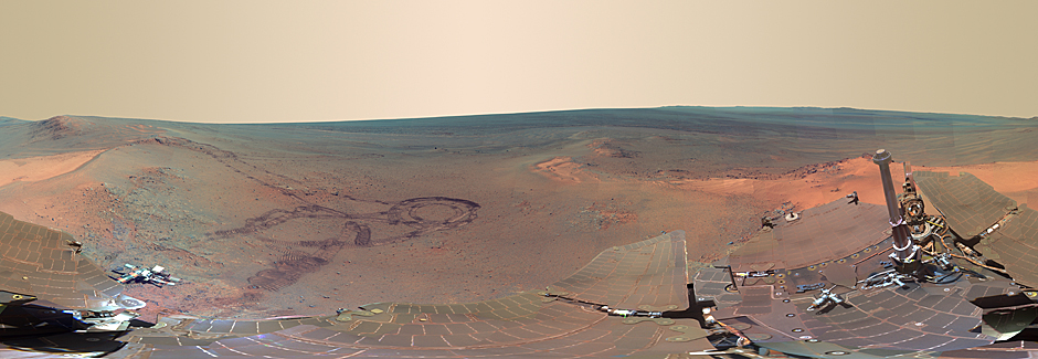
Image is courtesy of NASA and can be found at photojournal.jpl.nasa.gov/catalog/PIA15689
By NZHearld.co.nz
Comments
Before you add a new comment, take note this story was published on 8 Jul 2012.
Latest Video

VIDEO: Severe weather risks for NZ as low moves in
Programming Note: Apologies but we have no video on Thursday – back again on Friday! – A storm in the…
Related Articles

VIDEO: ClimateWatch: July is the month of BIG lows, BIG highs
This month around New Zealand, Australia and the region we see big highs and big lows – bringing decent stretches…

VIDEO (NZ): Large low looms – who gets rain/wind & who does not
Another large low will bring severe weather to parts of both main islands of NZ this week, followed by a…

WeatherWatchTV on YouTube climbs over 100K subscribers, joins global club of just 0.7%
WeatherWatchTV now has over 100,000 subscribers, larger than Australia’s Bureau of Meteorology and far exceeding the NZ Government’s Niwa Weather…


Add new comment