Labour Weekend, where is the rain going to be and where is the sun?
20/10/2017 2:29am

> From the WeatherWatch archives
The short of it is some eastern regions will get the best weather this Labour Weekend, central parts of the country are looking the driest. For the long version, read on….
Lets start with Saturday, here’s a rain map for 1pm

A front pushes northwards over the South Island during the day reaching the North Island in the evening. For the West Coast of the South Island it’s looking a bit wet so to speak, some sun may start to break through about South Westland later in the day once this front clears. Southland and Otago sees morning rain clear then some afternoon sun moves in, overnight further rain moves in with another frontal system. Canterbury has a good first half of the day then cloud and a few showers move in from afternoon with a southerly change. Marlborough and Nelson are looking quite good, expect some high cloud and north to northwesterly winds. Marlborough sees high’s reaching into the mid 20’s, that southerly flick doesn’t move in till later in the day and even then it’s looking fairly dry.
For the North Island expect cloudy areas in the west, chance of a shower at times from afternoon then showers are more likely in the evening as that front closes in. The east coast has a great day with high’s into the mid 20’s, mainly sunny conditions and light winds.
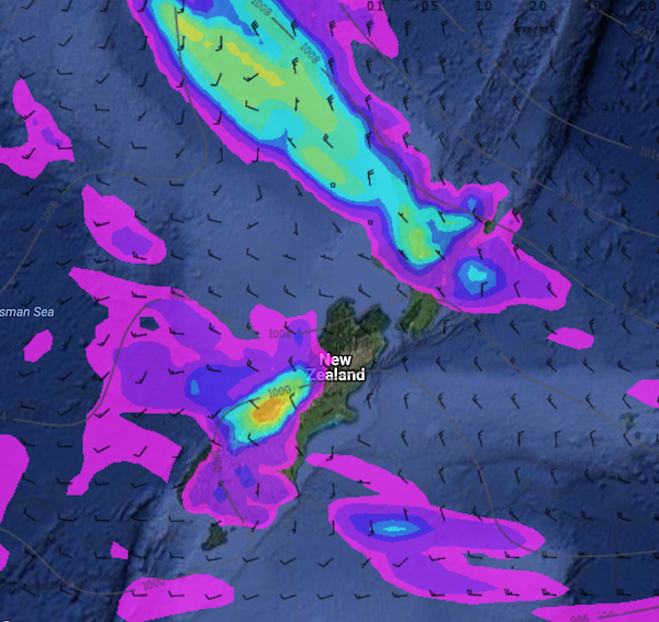
Moving along to Sunday, a map here for 1pm.

For the West Coast of the South Island expect a mainly cloudy day with areas of rain or showers, dry areas becoming more frequent from afternoon. Southland and Otago sees some cloud and the odd shower, showers more likely early in the morning then again later in the evening, during the day showers are more confined to coastal Southland and inland western parts of Otago. Canterbury has a fairly good morning, light winds tending southerly in the afternoon bringing some cloud Banks Peninsula southwards. Marlborough can expect mainly sunny weather, some cloud about Nelson with showers for the northwest Nelson / Tasman area.
Fairly cloudy about the upper North Island, a few morning showers clear for most however the odd one lingers for Northland. These Northland showers push back into Auckland, Waikato and Bay Of Plenty later in the evening or overnight due to a feed of moisture coming in from the tropics. The lower western North Island has morning cloud break to sunny spells. Another great day for the east coast with sunny areas and some high cloud, warm afternoon temperatures.
Finally looking at Monday, a map here for 1pm.
This time New Zealand is having the squeeze put on at both ends. A front drifting in from the tropics brings a mainly wet / rainy day for the upper North Island, there could be an isolated heavy fall or two. At least it won’t be all that cold so one has to look on the bright side right? Some rain spilling into Hakwes Bay and Gisborne at times also but there will be areas of dry too. Just at the bottom of the North Island, Waiararpa and Wellington should stay mainly dry with some high cloud.
Looking wet for the West Coast of the South Island with areas of heavy rain, rain or showers for Southland and Otago for much of the day with south to southwest winds. Canterbury is looking mainly sunny with some high cloud however southwesterlies push in late afternoon or evening bringing some cloud and a few showers. Marlborough and Nelson is looking quite good with a touch of high cloud, just watch for a few late evening showers moving into the northwest Nelson / Tasman areas.
So there we go, not really the best outlook for some, especially in the west. Roll on summer.
WeatherWatch.co.nz
Images – weathermap.co.nz
Latest Video

Matariki, the long weekend + the outlook for next week
Wet weather and cloud continues along the eastern side of the country with the heaviest rain now moving into northern…
Related Articles
Matariki, the long weekend + the outlook for next week
Wet weather and cloud continues along the eastern side of the country with the heaviest rain now moving into northern…

More eastern rain, but a drier long weekend coming
Rain continues today along the eastern South Island and lower North Island, coming in from the east with heavy falls….

More heavy rain, snow – but large dry areas, especially as we go into the long weekend
Heavy rain will continue for parts of Canterbury and Marlborough over the next day or two and it will gradually…

