It’s that time of year where the highs are here, but the lows won’t go away (x8 Maps)
4/11/2017 4:10am

> From the WeatherWatch archives
NEXT FOUR DAYS — We’ve reached that point in spring where the anticyclones (highs) are draped like a chain-link-fence around our part of the world. To the north and south of this high pressure belt are lows, which occasionally push through the “chain link fence” where the highs meet/touch.
Northern Australia is staying under relatively low pressure conditions, which deepens at midday allowing stray thunderstorms. The Antarctic troughs are deepening over the Tasman Sea and are hitting New Zealand every three days.
Those lows/troughs almost always accompany cold fronts which tend to be long and sharp.
In recent set ups those fronts look as though they bridge Sydney and main centres in New Zealand. The set up of fronts between Sydney and New Zealand continues over the next few days as spring reminds us “I’m only half way through”.

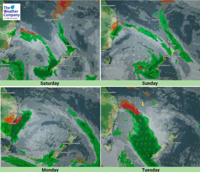

– Images / The Weather Company (An official WeatherWatch.co.nz business partner)
– WeatherWatch.co.nz
Latest Video

Cold weekend, frosts return with high pressure, then a low late next week
The subantarctic airflow spreads over NZ today/tonight and into Saturday, dropping temperatures nationwide. Snow flurries are possible today to lower…
Related Articles
Cold weekend, frosts return with high pressure, then a low late next week
The subantarctic airflow spreads over NZ today/tonight and into Saturday, dropping temperatures nationwide. Snow flurries are possible today to lower…

Wintry burst of weather: Snow, squally showers then sunshine & frosts
A polar change (another one!) arrives on Friday for the South Island and goes nationwide on Saturday, leaving NZ under…

Antarctic southerly for parts of NZ Fri & Sat
For the first time this year a southerly from off Antarctica is heading towards the South Island, followed by more…

