International Weather Headlines: India heat, Japan rain, big dry across Australia / NZ (+3 maps)
20/05/2019 1:50am

> From the WeatherWatch archives
High temperatures are coming for India, more heavy rain for Japan and a huge high pressure system for Australia and NZ means a lot of dry weather in the week ahead.
Here’s a quick glance at the weather stories make the news this week around Asia and the Pacific.
Each week WeatherWatch.co.nz will now be using our international partners to bring you more global weather headlines, especially from Australia, Asia, across the Pacific and North America.
- INDIA
While maximum temperatures in Indian’s northern and central plains will be average or cooler than average in the week ahead maximum temperatures elsewhere will be very hot. Temperatures of more than 40C will continue to persist over western, central, southern, and eastern India. In fact, some pockets of Vidarbha will experience more than 45C this week.

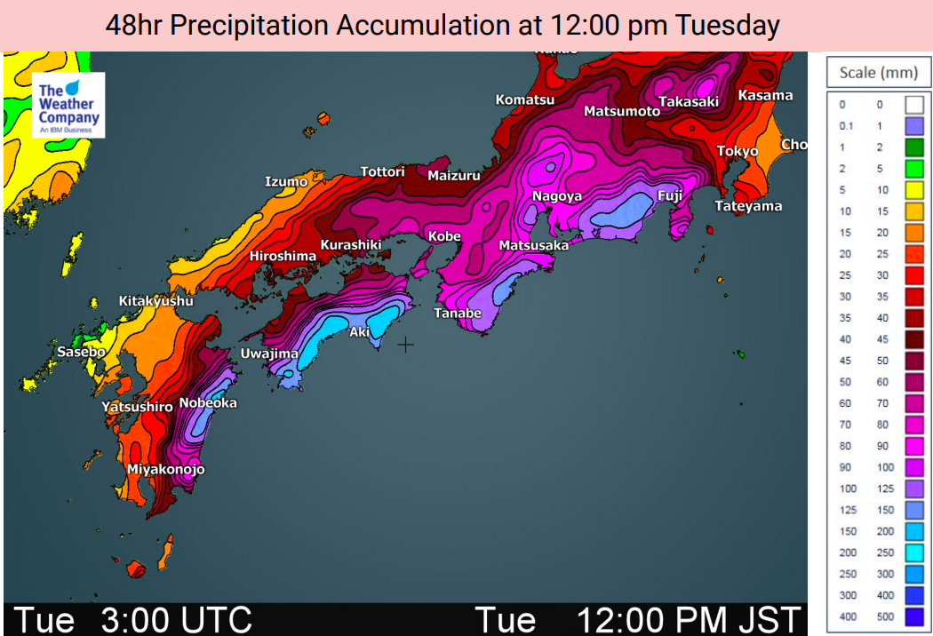
- JAPAN
Persistent high pressure over the Pacific Ocean finally pulls away eastwards this week allowing low pressure to advance into Japan. Moderate to heavy rain starts initially over South Korea, Kyusyu, Cyugoku, and Shikoku and spreads into eastern and northern Japan across Monday and Tuesday. Some heavy rain will remain into Wednesday.
Down south and Miyazaki will experience very intense rainfall rates of 100 mm/12 hours on Monday morning and Kouch and Nansei Islands also 100 mm/12 hours across Monday. Thunderstorms are very likely to accompany the rain. Yakushima already received an incredible 450mm (almost half a metre of rain!) on Saturday. Due to huge rainfall totals there is a risk of flooding, mudflow, rock fall and other landslides during and immediately after rain in these areas.
Heavy rain is also likely in some pockets of Tokushima, Mie, Gifu, and Aichi from Monday evening to Tuesday morning and Shizuoka on Tuesday.
- AUSTRALIA & NZ
An enormous belt of high pressure is forming this week across Australia, the Tasman Sea and northern New Zealand. Roughly it will cover a distance from west to east of 9000kms (but the anticyclone isn’t very large from north to south, allowing some rain to track into the western South Island of New Zealand and Tasmania in Australia.
This huge area of high pressure is due to two anticyclones merging and creating a much drier than normal weather pattern for the next several days.

– Maps courtest of IBM/The Weather Company and the US Government.
– WeatherWatch.co.nz
Latest Video

Cold weekend, frosts return with high pressure, then a low late next week
The subantarctic airflow spreads over NZ today/tonight and into Saturday, dropping temperatures nationwide. Snow flurries are possible today to lower…
Related Articles
Cold weekend, frosts return with high pressure, then a low late next week
The subantarctic airflow spreads over NZ today/tonight and into Saturday, dropping temperatures nationwide. Snow flurries are possible today to lower…

Wintry burst of weather: Snow, squally showers then sunshine & frosts
A polar change (another one!) arrives on Friday for the South Island and goes nationwide on Saturday, leaving NZ under…

Antarctic southerly for parts of NZ Fri & Sat
For the first time this year a southerly from off Antarctica is heading towards the South Island, followed by more…

