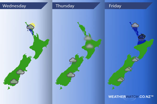
InfoGraphic: The main Weather News Highlights across NZ: Wed, Thu, Fri
30/05/2017 7:00pm

> From the WeatherWatch archives
A weak low pressure system passes over the North Island today while a light south to southwesterly airflow spreads over New Zealand. A weak ridge on Thursday then a low gradually somersaults onto the North Island on Friday spinning out of the Tasman Sea while a ridge continues in the south.
Wednesday
Blue – Risk of a few isolated heavy falls about western Northland this morning then gradually easing.
Patchy showers or drizzle about Otago moves into South and Mid Canterbury this afternoon.
Thursday
A fairly settled day across New Zealand, there may be some morning fog about the North Island especially inland.
Showers about North Westland, low risk of an isolated heavy fall. Drizzle continues about North Otago and South / Mid Canterbury.
Friday
Blue – Rain moves onto Northland late morning then eases during the afternoon, as rain makes it’s way down to Auckland / Waikato late afternoon it may become heavy then easing overnight.
A fairly cloudy day about the eastern North Island.
– Please note, the idea behind this update is to focus on the main weather highlights, which is why not all regions are mentioned.
For specific 10 day information for your city, town, rural community or island please see the 1500 forecasts on our homepage!
– Aaron Wilkinson, WeatherWatch.co.nz
Latest Video

Wintry weather coming: Snow, rain, wind & sunshine
A cold front is moving into NZ from Friday to Sunday with low pressure developing west of NZ and then…
Related Articles

Polar airflow + northern low = pockets of heavy rain & snow
A colder change is coming – and so too is a large low which will develop and grow over northern…
Wintry weather coming: Snow, rain, wind & sunshine
A cold front is moving into NZ from Friday to Sunday with low pressure developing west of NZ and then…

ClimateWatch: JULY outlook & what El Niño means for NZ
El Niño is officially here and still getting stronger in the months ahead, but it’s harder to notice its effects…

