InfoGraphic: The Main Weather News Highlights across NZ: Tue, Wed, Thu
17/07/2017 7:00pm

> From the WeatherWatch archives
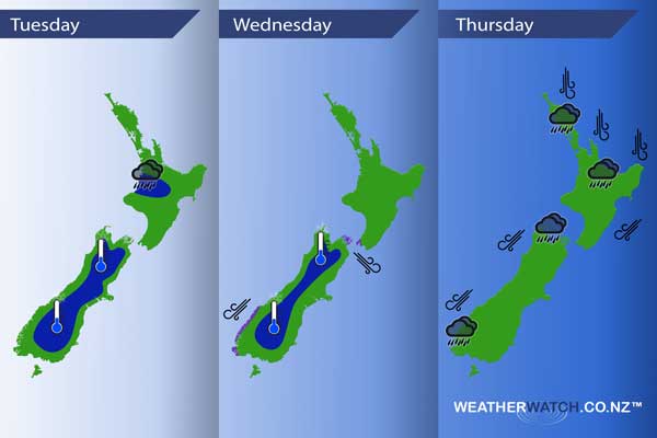
A front weakens over the North Island today meanwhile a ridge brings mainly settled weather further south. A northerly airflow gradually increases on Wednesday. A front moves in from the west on Thursday with a strong north to northeasterly airflow preceding it.
Tuesday
Blue – Rain about the upper North Island may be heavy early this morning then easing away.
A frosty start for much of the inner South Island, generally no major frosts with 0 to -2 degrees most common. -4 isn’t out of the question in some isolated inland spots.
Wednesday
Blue – Another frosty start about a thinner slice of the inner South Island, no major frosts.
Purple – As a northerly quarter airflow increases over New Zealand during the day northwesterly winds becoming gusty through Cook Strait and northeasterlies strong about coastal Fiordland from afternoon.
Thursday
A deep low forms moving into position west of the South Island on Thursday. Hooked into this low is a front which moves in from the west delivering heavy rain about the upper North Island and Nelson / Tasman before easing later in the evening. Rain about South Westland may be heavy then easing from afternoon.
North to northeasterly winds preceding this front are quite strong with gales likely about coastal areas especially about northeastern parts of the North Island.
– Please note, the idea behind this update is to focus on the main weather highlights, which is why not all regions are mentioned.
For specific 10 day information for your city, town, rural community or island please see the 1500 forecasts on our homepage!
– Aaron Wilkinson, WeatherWatch.co.nz
Latest Video

Wintry weather coming: Snow, rain, wind & sunshine
A cold front is moving into NZ from Friday to Sunday with low pressure developing west of NZ and then…
Related Articles

Polar airflow + northern low = pockets of heavy rain & snow
A colder change is coming – and so too is a large low which will develop and grow over northern…
Wintry weather coming: Snow, rain, wind & sunshine
A cold front is moving into NZ from Friday to Sunday with low pressure developing west of NZ and then…

ClimateWatch: JULY outlook & what El Niño means for NZ
El Niño is officially here and still getting stronger in the months ahead, but it’s harder to notice its effects…

