InfoGraphic: The Main Weather News Highlights across NZ: Tue, Wed, Thu
10/07/2017 7:56pm

> From the WeatherWatch archives
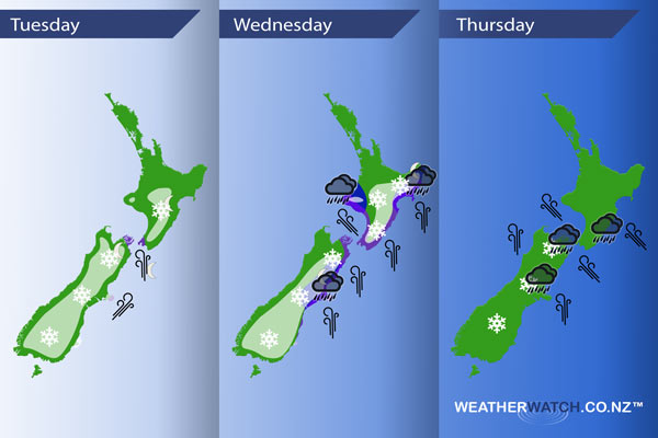
Early today a cold southwest change moves onto the lower South Island then pushes northwards to reach the lower North Island overnight. Wednesday sees a very cold southerly airflow cover New Zealand with a low deepening later in the day east of the North Island. A squash zone develops between the low about the eastern North Island and an incoming ridge creating very strong winds about central New Zealand and some heavy rain.
Tuesday
White – A cold southwest change hits Southland early this morning then reaches the lower North Island overnight. Generally speaking there will be some heavier snow with the change however this will be higher in the ranges then easing after a period of time to flurries, the snow level will lower with these lighter flurries. Parts of Canterbury north of about the Rakaia river through to northern North Canterbury may see some reasonable snow however for a longer period of time through the night. Some snow about Southland / Otago to 400m at first then lowering to low levels (200 to 100m) or perhaps even near sea level at times overnight. Snow lowers overnight to 200m about Canterbury, 400 or perhaps 300m at a push overnight for Marlborough / Nelson. The Wellington region may see flurries to 400m by dawn on Wednesday, the Central North Island sees flurries to 700m by dawn on Wednesday.
Purple – As this change pushes northwards expect a period of gusty southwesterlies about Banks Peninsula then overnight strong Southerlies develop through Cook Strait.
Wednesday
Blue – Rain heavy for a time about Taranaki in the afternoon, about Hawkes Bay / Gisborne in the evening and overnight. Rain about Mid and North Canterbury becoming more persistent from afternoon, heavy for a time later in the day / overnight.
White – Bitterly cold south to southwesterly winds bring snow flurries to low levels at times for much of the southern and eastern South Island. Flurries may reach to near sea level at times. Marlborough / Nelson will have a mainly dry day after any early showers clear. From afternoon snow about Mid and North Canterbury becomes heavy down to 200m.
Snow flurries about the Central North Island to 700m at first then lowering to 400m or perhaps even 300m in the afternoon, clearing in the evening. Flurries about the Wellington region to 300m clear around midday. Some snow lowers to 300m for a time about the Wairarapa, 500 or perhaps 400m about Hawkes Bay then 600m in the evening for Gisborne about the ranges.
Purple – Southerly winds strengthen during the day through central and eastern New Zealand, gusting to gale at times about coastal areas especially afternoon onwards.
Thursday
Heavy rain affects parts of Central New Zealand on Thursday, winds becoming very strong from the south or southeast with severe gales likely especially through the Cook Strait area. Snow flurries lightest about Otago / South Canterbuy (to low levels), gradually easing and clearing later in the evening / overnight. Heavier rain / snow about Mid, North Canterbury and Marlborough to 300m eases from afternoon. Snow will vary between 400 and 300m about Marlborough.
– Please note, the idea behind this update is to focus on the main weather highlights, which is why not all regions are mentioned.
For specific 10 day information for your city, town, rural community or island please see the 1500 forecasts on our homepage!
– Aaron Wilkinson, WeatherWatch.co.nz
Comments
Before you add a new comment, take note this story was published on 10 Jul 2017.
Latest Video

NZ VIDEO: Severe weather going into the weekend. Next week: Westerlies continue
Heavy rain and northerly gales are moving across NZ going into the weekend as a large low from the Tasman…
Related Articles
NZ VIDEO: Severe weather going into the weekend. Next week: Westerlies continue
Heavy rain and northerly gales are moving across NZ going into the weekend as a large low from the Tasman…

VIDEO: Low pressure, cold fronts, main feature next two weeks
There are several low pressure zones and cold fronts coming into NZ, with westerly driven weather dominating our weather pattern…

VIDEO: Burst of wind and rain for NZ as low pressure dominates
Air pressure around New Zealand will continue to drop in the days ahead as low pressure systems affect our weather…


Add new comment