InfoGraphic: The main Weather News Highlights across NZ: Tue, Wed, Thu
29/05/2017 7:00pm

> From the WeatherWatch archives
A ridge loses it’s grip over New Zealand today as a frontal system moves in from the west, the front makes landfall for western parts of the country during the afternoon and evening. A light south to southwesterly airflow lies over the country on Wednesday. A weak ridge for Thursday.
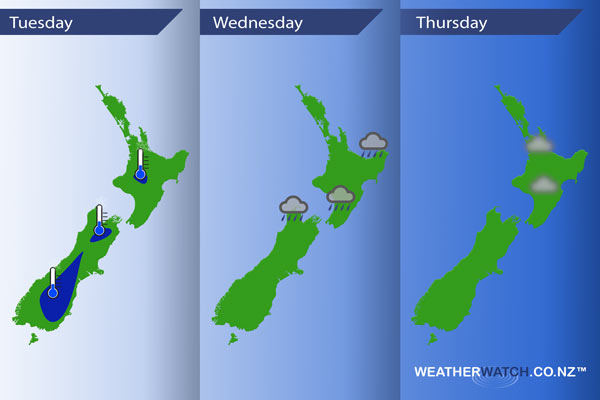
Tuesday
Blue – A few cold spots this morning around dawn, around the 2 to 0 degree celsius mark.
As a front moves onto the West Coast of the South Island in the afternoon there may be a few spots of heavy rain although nothing out of the ordinary for the West Coast.
Wednesday
Rain or showers about the North Island and Tasman ease during the morning and clear by midday, low risk of a heavy fall.
Thursday
A fairly settled day across New Zealand, there may be some morning fog about the North Island especially inland.
– Please note, the idea behind this update is to focus on the main weather highlights, which is why not all regions are mentioned.
For specific 10 day information for your city, town, rural community or island please see the 1500 forecasts on our homepage!
– Aaron Wilkinson, WeatherWatch.co.nz
Latest Video

Wintry weather coming: Snow, rain, wind & sunshine
A cold front is moving into NZ from Friday to Sunday with low pressure developing west of NZ and then…
Related Articles

Polar airflow + northern low = pockets of heavy rain & snow
A colder change is coming – and so too is a large low which will develop and grow over northern…
Wintry weather coming: Snow, rain, wind & sunshine
A cold front is moving into NZ from Friday to Sunday with low pressure developing west of NZ and then…

ClimateWatch: JULY outlook & what El Niño means for NZ
El Niño is officially here and still getting stronger in the months ahead, but it’s harder to notice its effects…

