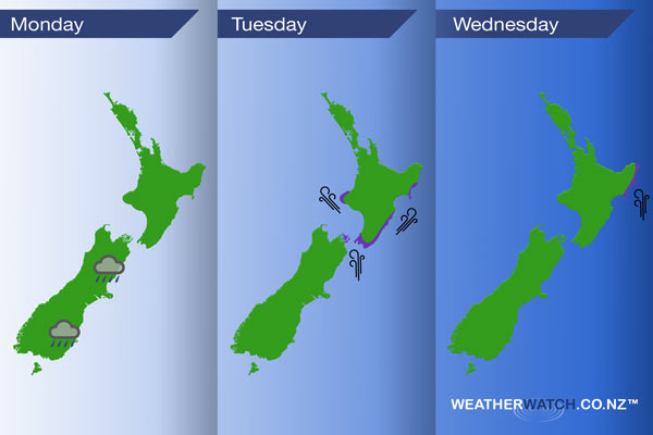
InfoGraphic: The main Weather News Highlights across NZ: Mon, Tue, Wed
12/03/2017 6:00pm

> From the WeatherWatch archives
Low pressure weakens a little over New Zealand today, the airflow is mainly from the south or southwest. On Tuesday a low east of the country brings a continuing southerly quarter airflow then on Wednesday a high moves over the South Island while southeasterlies lie over the North.
Monday
No risky weather today however shower / rain activity in the east of the South Island continues which will bring much needed relief to some dry parts of Canterbury.
Tuesday
Purple – Southerlies becoming strong about Wellington after midday, a chance of winds gusting to gale at times. Southeasterlies becoming gusty about Taranaki late afternoon / evening. During the afternoon and evening strong coastal southwesterly winds spread northwards along the east coast of the North Island, winds may gust to gale at times right on the coastal fringes.
Wednesday
Purple – Strong southerly winds about coastal Gisborne and East Cape gradually ease during the day.
– Please note, the idea behind this update is to focus on the main weather highlights, which is why not all regions are mentioned.
For specific 10 day information for your city, town, rural community or island please see the 1500 forecasts on our homepage!
– Aaron Wilkinson, WeatherWatch.co.nz
Latest Video

Temperature changes for some regions ahead of heavy West Coast rain
A nor-wester is about to kick in and it’s coming from out of Australia, boosting temperatures in some regions going…
Related Articles
Temperature changes for some regions ahead of heavy West Coast rain
A nor-wester is about to kick in and it’s coming from out of Australia, boosting temperatures in some regions going…

NZ 7 day forecast: Showers, temp changes and heavy West Coast rain
NZ has a fairly messy forecast over the next 7 days, but the main feature will be heavy rain on…

Cold fronts continue, wind & rain for some Fri/Sat
Wet weather is moving over the North Island today, while the South Island has drier skies – ahead of another…

