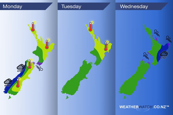
InfoGraphic: The main Weather News Highlights across NZ: Mon, Tue, Wed
5/02/2017 6:00pm

> From the WeatherWatch archives
A ridge lies over the upper North Island today while northwesterlies strengthen over the rest of New Zealand. A front moves onto the lower South Island later this afternoon / evening then northwards overnight. This front reaches the lower North Island in the afternoon then slowly moves over the rest of the North Island on Wednesday.
Monday
Blue – Heavy rain moves into Fiordland this morning then reaching North Westland this evening.
Purple – Northwesterlies pick up across much of the South Island this afternoon, possibly even breezy or a bit gusty at times. Through the Cook Strait area northwesterlies strengthen rising to gale later today.
Yellow – High’s in the early 30’s for the east of the South Island today, low to mid 30’s for the east of the North Island. Mid to high 20’s for most other areas marked in yellow below.
Tuesday
Yellow – Temperatures reaching into the early 30’s on Tuesday for the east of the North Island and about Northland. Mid to late 20’s elsewhere.
Wednesday
Blue – Rain about the eastern North Island may be persistent, it may not be all that heavy however since no rain has fallen about the east of the North Island for a while this is definitely welcome news.
Purple – Southeasterlies becoming brisk to strong for the areas marked in purple below.
– Please note, the idea behind this update is to focus on the main weather highlights, which is why not all regions are mentioned.
For specific 10 day information for your city, town, rural community or island please see the 1500 forecasts on our homepage!
– Aaron Wilkinson, WeatherWatch.co.nz
Latest Video

Wintry weather coming: Snow, rain, wind & sunshine
A cold front is moving into NZ from Friday to Sunday with low pressure developing west of NZ and then…
Related Articles

Polar airflow + northern low = pockets of heavy rain & snow
A colder change is coming – and so too is a large low which will develop and grow over northern…
Wintry weather coming: Snow, rain, wind & sunshine
A cold front is moving into NZ from Friday to Sunday with low pressure developing west of NZ and then…

ClimateWatch: JULY outlook & what El Niño means for NZ
El Niño is officially here and still getting stronger in the months ahead, but it’s harder to notice its effects…

