InfoGraphic: The Main Weather News Highlights across NZ: Fri, Sat, Sun
30/11/2017 6:00pm

> From the WeatherWatch archives
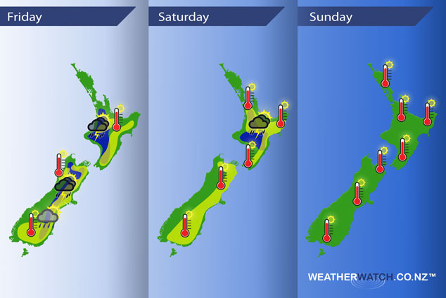
An anticyclone continues to cover New Zealand today, watch once again for inland downpours / thunderstorms during this afternoon and evening. Saturday sees a northwesterly airflow start to develop over the South Island, this brings a reduced risk of heavy inland showers for the South Island but hot temperatures in the east. Sunday sees hot temperatures and northwesterlies for most of the country however a ridge lies over the upper North Island.
Friday
Blue – Isolated showers developing for inland areas of both islands in the afternoon / evening, some may contain thunderstorms / heavy falls and perhaps a risk of hail.
Yellow – High’s reaching into the low 20’s across many parts of New Zealand, perhaps the mid to even late twenties for some areas (late twenties more likely about inland Southland / Central Otago).
Saturday
Blue – An end to heavy showers for the South Island on Saturday however they may brew up again about inland parts of the North Island in the afternoon bringing a risk of thunderstorms.
Yellow – Hot temperatures for eastern parts of both islands with high’s in the high twenties, perhaps even early thirties for the eastern South Island.
Sunday
Temperatures reaching into the mid to late twenties for many parts of eastern New Zealand on Sunday, also for most of the North Island. Some eastern parts of the South Island will reach into the early thirties.
– Please note, the idea behind this update is to focus on the main weather highlights, which is why not all regions are mentioned.
For specific 10 day information for your city, town, rural community or island please see the 1500 forecasts on our homepage!
– Aaron Wilkinson, WeatherWatch.co.nz
Latest Video

Wintry weather coming: Snow, rain, wind & sunshine
A cold front is moving into NZ from Friday to Sunday with low pressure developing west of NZ and then…
Related Articles

Polar airflow + northern low = pockets of heavy rain & snow
A colder change is coming – and so too is a large low which will develop and grow over northern…
Wintry weather coming: Snow, rain, wind & sunshine
A cold front is moving into NZ from Friday to Sunday with low pressure developing west of NZ and then…

ClimateWatch: JULY outlook & what El Niño means for NZ
El Niño is officially here and still getting stronger in the months ahead, but it’s harder to notice its effects…

