InfoGraphic: The Main Weather News Highlights across NZ: Fri, Sat, Sun
31/08/2017 7:00pm

> From the WeatherWatch archives
A low east of New Zealand directs a southerly quarter airflow over the South Island and lower North Island today. The upper North Island mostly has low pressure which becomes more organised overnight as a low centre moves in from the northwest. Saturday sees this low move onto the upper North Island from the north while a ridge starts to make some headway further south. Southerlies over the North Island on Sunday, high pressure further south.
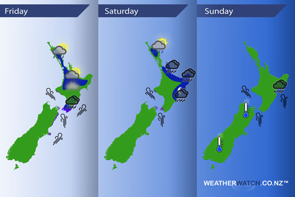
Friday
Blue – Isolated showers develop this afternoon about inland parts of the upper North Island, some may become heavy especially about the Waikato then easing later on. Chance of a thunderstorm also.
Early heavy rain about the lower North Island eases.
Purple – Southerly quarter winds about the lower North Island and outer parts of Banks Peninsula are brisk to strong, winds may gust to gale at times through Cook Strait.
Not much wind and high moisture brings a risk of fog this morning about the upper North Island, generally where skies are clear the night before. If areas of low cloud persist through the night fog may keep at bay.
Saturday
Blue – As a low swings down over the North Island during the day some rain about the Coromandel and Bay Of Plenty (possibly heavy) gradually moves into East Cape by midday then Gisborne / Hawkes Bay during the evening and overnight.
Showers about Northland may be heavy for a time early to mid afternoon as a southwest change pushes through.
Purple – Southerlies through Cook Strait continue to be brisk / strong during the day.
Sunday
Rain about the eastern North Island may be heavy in the morning then easing from afternoon, mainly about Hawkes Bay and Gisborne. Gusty southerlies through Cook Strait and about the eastern North Island ease during the day.
Finally a frosty start is in store for some inland parts of the South Island that manage to clear up before dawn.
– Please note, the idea behind this update is to focus on the main weather highlights, which is why not all regions are mentioned.
For specific 10 day information for your city, town, rural community or island please see the 1500 forecasts on our homepage!
– Aaron Wilkinson, WeatherWatch.co.nz
Latest Video

Wintry weather coming: Snow, rain, wind & sunshine
A cold front is moving into NZ from Friday to Sunday with low pressure developing west of NZ and then…
Related Articles

Polar airflow + northern low = pockets of heavy rain & snow
A colder change is coming – and so too is a large low which will develop and grow over northern…
Wintry weather coming: Snow, rain, wind & sunshine
A cold front is moving into NZ from Friday to Sunday with low pressure developing west of NZ and then…

ClimateWatch: JULY outlook & what El Niño means for NZ
El Niño is officially here and still getting stronger in the months ahead, but it’s harder to notice its effects…

