
> From the WeatherWatch archives
A front moves from west to east over the North Island tomorrow passing out to the east in the afternoon, meanwhile a weak area of low pressure covers the rest of New Zealand.
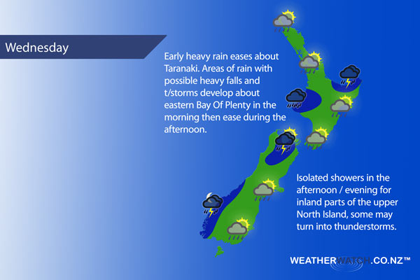
For the upper North Island we see morning areas of rain ease to the odd shower and sunny spells by midday as northerlies change breezy westerly, there may be an isolated heavy fall or two in the morning first thing. Eastern Bay Of Plenty may actually see heavy falls and thunderstorms from morning till early afternoon.
For the lower North Island in the west early rain with heavy falls about Taranaki eases to showers as northerlies change westerly, rain about Taranaki first thing may see a rumble of thunder. The east coast of the North Island sees scattered rain passing over from the west then clearing early afternoon with sun breaking through, the Wairarapa may see a shower linger till evening.
For the upper South Island we see morning rain or showers clear for most then sun breaking through, winds are from the south in the east and west in the west. Isolated showers developing about some parts of the interior of the South Island afternoon / evening, a few of these showers may even become heavy with thunderstorms (mainly about inland Nelson).
For the lower South Island morning cloud breaks to mostly sunny weather, there may be a clearing early shower about northern parts of Otago. Once again inland there may be an isolated shower or two late afternoon / evening otherwise remaining fairly dry with high cloud thickening in the evening. Rain with heavy falls and thunderstorms move into South Westland overnight.
While there is the chance still of a light frost first thing about the lower South Island the risk is not as present due to potential cloud hanging on slightly longer early in the morning. So instead of 1 or 0 degrees first thing it may end up being a degree or two warmer.
Not all regions and towns have been mentioned above. For specific 10 day information for your city, town, rural community or island please see the 1500 forecasts on our homepage!
– Aaron Wilkinson, WeatherWatch.co.nz
Comments
Before you add a new comment, take note this story was published on 1 Nov 2016.
Latest Video

NZ VIDEO: Severe weather going into the weekend. Next week: Westerlies continue
Heavy rain and northerly gales are moving across NZ going into the weekend as a large low from the Tasman…
Related Articles
NZ VIDEO: Severe weather going into the weekend. Next week: Westerlies continue
Heavy rain and northerly gales are moving across NZ going into the weekend as a large low from the Tasman…

VIDEO: Low pressure, cold fronts, main feature next two weeks
There are several low pressure zones and cold fronts coming into NZ, with westerly driven weather dominating our weather pattern…

VIDEO: Burst of wind and rain for NZ as low pressure dominates
Air pressure around New Zealand will continue to drop in the days ahead as low pressure systems affect our weather…


Add new comment