> From the WeatherWatch archives
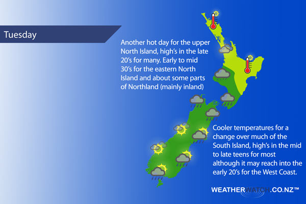
A front moves over the upper South Island on Tuesday, onto the lower North Island during the afternoon / evening. The airflow is generally from the northwest ahead of the front and from the south in behind.
For Northland it’s a mainly sunny day with afternoon sea breezes and hot temperatures. Auckland, Waikato and the Bay Of Plenty are a bit cloudier, some sun may break through now and then, winds mostly from the west of northwest. There may be a brief shower or drizzle patch now and then also, mainly about the Waikato.
The lower North Island in the west sees cloudy skies with drizzle then some rain late afternoon or evening. The east coast is hot an sunny with northwesterlies, some rain moves into the Wairarapa during the afternoon then into Hawkes Bay later in the evening / overnight with a southerly change. A southeast change in the morning for Wellington brings areas of rain which ease in the evening.
Nelson and Marlborough see rain for much of the day, clearing in the evening. Canterbury has morning rain or showers then clearing in the afternoon, there is the chance of a remaining drizzle patch at times. Later in the evening or overnight further showers or some rain may move into South Canterbury for a time. Morning rain or showers for North Westland then cloud breaks to some sun later in the day, South Westland sees morning high cloud clear to mainly sunny weather.
Southland and Otago sees a mix of sun and cloud, the odd shower possible more so from afternoon. Some rain or more persistent showers develops about North Otago in the evening then eases overnight.
Blue – Heavy form of precipitation.
Purple – Strong winds
Yellow – Temperatures around the mid 20 degree mark or over.

Not all regions and towns have been mentioned above. For specific 10 day information for your city, town, rural community or island please see the 1500 forecasts on our homepage!
– Aaron Wilkinson, WeatherWatch.co.nz
Comments
Before you add a new comment, take note this story was published on 6 Feb 2017.


Add new comment