InfoGraphic: The Big Picture for Wednesday / Thursday
30/01/2018 6:00pm

> From the WeatherWatch archives
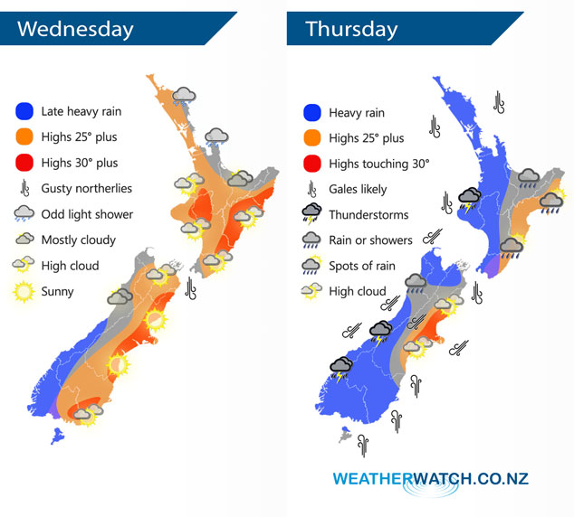
Today sees an increasing northerly quarter airflow over New Zealand while Ex Tropical Cyclone Fehi drops into the Tasman Sea from the tropics, this deep and large low affects the country on Thursday bringing gale winds and heavy rain for the South Island. Heavy rain may also affect the North Island from afternoon in the west.
Today sees nice and hot weather especially for the eastern South Island, later in the evening or overnight heavy rain starts to move onto the western / lower South Island.
On Thursday heavy rain with torrential falls affects the west of the South Island, thunderstorms are possible also. Rain may be heavy for the western North Island from afternoon then easing overnight. Winds are strong to gale force from the north for many regions, southerlies strengthen about the lower South Island during the day. Severe gales are very possible about many coastal areas and the inner South Island during the day.
By Weather Analyst Aaron Wilkinson – WeatherWatch.co.nz
Latest Video

Matariki, the long weekend + the outlook for next week
Wet weather and cloud continues along the eastern side of the country with the heaviest rain now moving into northern…
Related Articles
Matariki, the long weekend + the outlook for next week
Wet weather and cloud continues along the eastern side of the country with the heaviest rain now moving into northern…

More eastern rain, but a drier long weekend coming
Rain continues today along the eastern South Island and lower North Island, coming in from the east with heavy falls….

More heavy rain, snow – but large dry areas, especially as we go into the long weekend
Heavy rain will continue for parts of Canterbury and Marlborough over the next day or two and it will gradually…

