
> From the WeatherWatch archives
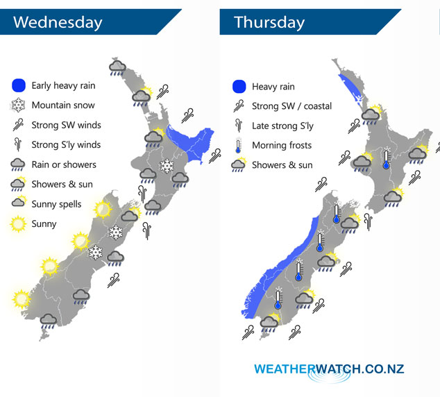
A strong cold southwesterly airflow covers New Zealand today, easing over the South Island later in the day as a ridge of high pressure starts to push in. The ridge quickly moves on on Thursday as a front moves onto the lower South Island late morning, reaching the North Island in the evening.
Rain or showers for most regions today however the West Coast of the South Island and Nelson gets a sunny day. Winds are strong from the south or southwest for many areas, easing from the south this evening.
Snow to 400m for eastern South Island regions gradually lifts during the day, flurries to 500m for hills and ranges about the Central Plateau and southwards in the North Island gradually lift during the day also.
Watch out for frosty conditions overnight especially about the inner South Island. These frosty conditions are naturally present on Thursday morning.
Rain pushes northwards over the South Island during Thursday, a chance of some heavy rain in the west with only showers or a few spots out east. Rain moves onto the western North Island in the evening.
Strong southwesterlies about the eastern North Island ease in the morning, in the west southwesterly winds become strong there later in the evening. For the South Island it’s not till late afternoon or evening that strong southwesterlies push northwards along the east coast.
By Weather Analyst Aaron Wilkinson – WeatherWatch.co.nz
Latest Video

Frosts, late week rain & another cold weekend coming
High pressure will cross NZ over the next few days meaning more cold nights/mornings with frosts, but a nor’wester will…
Related Articles
Frosts, late week rain & another cold weekend coming
High pressure will cross NZ over the next few days meaning more cold nights/mornings with frosts, but a nor’wester will…

NZ: Cold & windy, then calm & frosty
Downpours, some squally with the chance of thunderstorms and even small tornadoes are possible for parts of NZ over Friday…

WeatherWatch App launches real-time local lightning tracker
A bolt out of the blue! WeatherWatch has launched a live, real-time lightning tracker, enabling Kiwis to gain access to data provided by the…

