InfoGraphic: The Big Picture for Wednesday / Thursday
30/01/2018 3:00am

> From the WeatherWatch archives
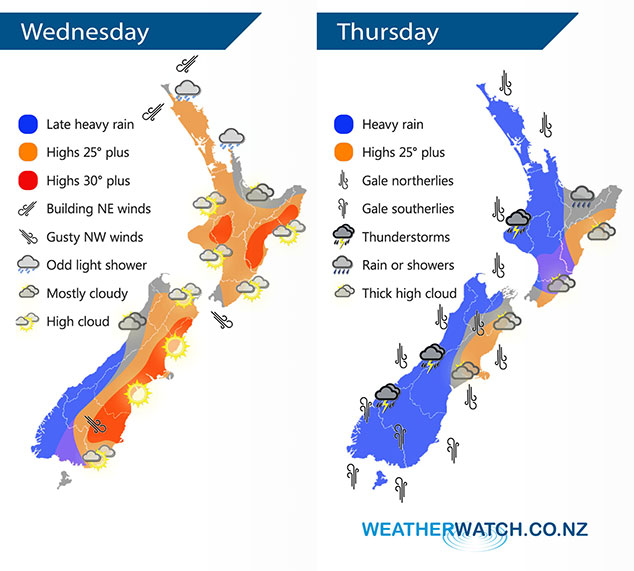
Wednesday sees an increasing northerly quarter airflow over New Zealand while a deepening low drops into the Tasman Sea from the tropics, this deep and large low affects the country on Thursday bringing gale winds and heavy rain for the South Island. Heavy rain may also affect the North Island from afternoon.
Plenty going on in the coming days due to a very tightly packed and deep low that affects the country on Thursday then weakens on Friday. Wednesday is a transition day before the low moves in, for many though it will still be a nice day and hot especially for the eastern South Island, later in the evening or overnight heavy rain starts to move onto the western / lower South Island.
On Thursday heavy rain with torrential falls affects the west of the South Island, thunderstorms are possible also. Rain may be heavy for the western North Island from afternoon then easing overnight. Winds are strong to gale force from the north for many regions, southerlies strengthen about the lower South Island during the day. The strongest winds overall will be for the western and northern South Island, also Taranaki where severe gale are likely.
By Weather Analyst Aaron Wilkinson – WeatherWatch.co.nz
Comments
Latest Video

Wintry weather coming: Snow, rain, wind & sunshine
A cold front is moving into NZ from Friday to Sunday with low pressure developing west of NZ and then…
Related Articles
Wintry weather coming: Snow, rain, wind & sunshine
A cold front is moving into NZ from Friday to Sunday with low pressure developing west of NZ and then…

ClimateWatch: JULY outlook & what El Niño means for NZ
El Niño is officially here and still getting stronger in the months ahead, but it’s harder to notice its effects…

Low pressure heading to NZ this weekend & into next week
Many regions have settled weather at the moment with frosts as far north as Auckland this morning, but still some…


Guest on 30/01/2018 6:45am
Love your two maps for Wednesday and Thursday. It’s so good not having to guess at what is shown on weather maps. The key on the left hand side is great.
Well done Aaron. Thank you.
WW Forecast Team on 30/01/2018 12:15pm
That’s great to hear, thankyou so much! Took a bit to get these maps going so am very happy you like them 🙂
Cheers
Aaron
Guest on 30/01/2018 5:10am
I cannot believe that warm Summer temps is the leading item on news today.
One source tells us – “what you should know”
Sick of it.
it is Summer and it does get warm in Summer.
We are told to prepare for more extreme heat due to climate change.utter bollocks – get used to having Summer for a change.
Temps warmer than average since records began, when did records begin in comparison to millions of years of temps up and down.
There are more important items of news to be reporting on instead of a nice run of Summer weather.
Thats my rant sorry!
Roll on Winter.
WW Forecast Team on 30/01/2018 5:38am
Your rant is fine “Roll on Winter” 🙂 . You may find all this focus on heat came from NIWA which is now aggressively competing against MetService (and both use your tax dollars to do so). NIWA (A Government agency which is not our official forecaster) said today would reach 40C and may break records – in fact we were 5 degrees from the national record which is a long way off. However this is why there’s been so much media coverage. The NZ Government is now officially looking into why NIWA is doing this – but they are fairly relaxed about it by saying they won’t reach a decision until the end of the year despite an official Government report a year ago saying change should happen to improve accuracy.
Cheers 🙂
WW