InfoGraphic – The big picture for Tuesday: Heat, heavy rain & strong winds
26/03/2018 3:15am

> From the WeatherWatch archives
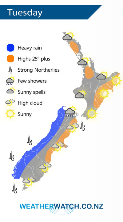
A cold front will move up the South Island on Tuesday caused by a low pressure system in the Southern Ocean.
This front will deliver slow moving heavy rain to the West Coast across the day, easing at night.
Winds ahead of the front will be strong, possibly gale in exposed areas, from the north to north west around Cook Strait and the Southern Alps.
This airflow will help push the temperature up in the east in both islands with Hawke’s Bay likely to climb into the late 20s C.
Elsewhere it should be a fairly pleasant, warm, Autumn day.
– By Aaron Wilkinson and Philip Duncan
– WeatherWatch.co.nz
Comments
Before you add a new comment, take note this story was published on 26 Mar 2018.
Latest Video

VIDEO: Burst of wind and rain for NZ as low pressure dominates
Air pressure around New Zealand will continue to drop in the days ahead as low pressure systems affect our weather…
Related Articles
VIDEO: Burst of wind and rain for NZ as low pressure dominates
Air pressure around New Zealand will continue to drop in the days ahead as low pressure systems affect our weather…

VIDEO: Severe weather late week as next low arrives
Another week, another big low is on the way from the Tasman Sea bringing wind and rain later this week,…

NZ VIDEO: High pressure gives way to windy, wetter, weather late week
Storms south of Australia will start to affect NZ later this week as an active cold front moves in, followed…


Add new comment