InfoGraphic: The Big Picture for Thursday / Friday
31/01/2018 6:00pm

> From the WeatherWatch archives
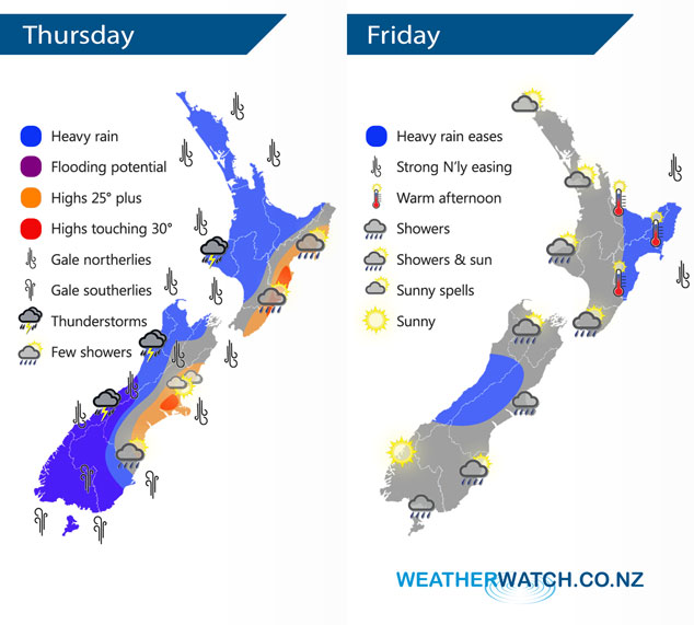
Ex Tropical Cyclone Fehi crosses over the South Island today bringing some very unsettled weather, a front connected into this low moves over the North Island from the west afternoon onwards. A southwesterly airflow covers the country on Friday.
As you can see the graphic for todays weather is very messy with plenty going on. The main focus will be about the lower and western South Island with very heavy rain on the agenda, areas of flooding look very possible. Strong northerly winds developing (severe gales likely) for most of the South Island, strong to severe gale southerlies develop about the lower South Island, more so from afternoon. Some heavy rain will cross the North Island afternoon / evening pushing in from the west.
Friday sees conditions ease across the country, some morning heavy rain eases about the northeast of the North Island and central parts of the South Island. Expect areas of cloud and the odd shower about otherwise. Winds from the southwest for most although northerlies gusty for the northeast of the North Island ease during the morning.
By Weather Analyst Aaron Wilkinson – WeatherWatch.co.nz
Comments
Latest Video

NZ: 8 Day outlook as gales & rain ease, high pressure builds
Damaging wind gusts and heavy rain will continue to affect some parts of the North Island and brushing Marlborough today…
Related Articles
NZ: 8 Day outlook as gales & rain ease, high pressure builds
Damaging wind gusts and heavy rain will continue to affect some parts of the North Island and brushing Marlborough today…

Pockets of hit & miss heavy rain, snow moves northwards
Low pressure continues to slowly move across the upper North Island and for some that will bring the sun out,…

Slow go for northern low & southern cold
For the next few days low pressure will crawl over the upper North Island, driving in rain as far south…


Anthony on 31/01/2018 7:47pm
Did you forget to add some purple to the map? I don’t see any ‘flooding potential’ areas on it.
WW Forecast Team on 31/01/2018 10:10pm
It’s the way the colours have overlayed and it changes them a bit, agreed though it’s not showing up as purple very well. I’ll have to look into tweaking that. It’s the darker area about Southland / Otago and running up the West Coast of the South Island.
Cheers
Aaron