InfoGraphic: The Big Picture for Saturday / Sunday
4/05/2018 7:40pm

> From the WeatherWatch archives
A northerly airflow increases over New Zealand on Saturday with a front pushing over the lower South Island from afternoon, reaching the lower North Island overnight. This front weakens and moves northeastwards over the North Island during Sunday, meanwhile another front lines up the lower South Island from afternoon pushing in from the southwest.
Mainly settled for the North Island on Saturday although cloud will start to build in the west, rain moves into the southwestern corner overnight. Cloudy for the West Coast of the South Island with the odd light shower, heavy rain moves into South Westland in the afternoon then pushes northwards in the evening. Drier out east although as a front passes over a few spots of rain may spread from the west, generally later in the day.
Early heavy rain about the western North Island moves away on Sunday as a front psuhes through, dry first thing elsewhere then showers or some rain develops during the morning then clears away during the afternoon. Northland may not see showers clear till evening however.
Cloudy for the west of the South Island again on Sunday, another front pushes in during the afternoon bringing heavy rain to South Westland. During the afternoon and evening a period of rain or showers moves through Southland and Otago, winds about coastal Southland will likely rise to gale from the west afternoon onwards.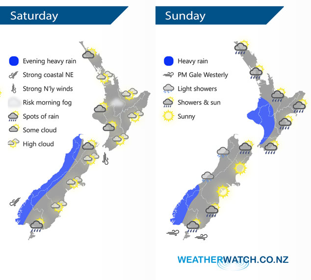
By Weather Analyst Aaron Wilkinson – WeatherWatch.co.nz
Latest Video

Pockets of hit & miss heavy rain, snow moves northwards
Low pressure continues to slowly move across the upper North Island and for some that will bring the sun out,…
Related Articles
Pockets of hit & miss heavy rain, snow moves northwards
Low pressure continues to slowly move across the upper North Island and for some that will bring the sun out,…

Slow go for northern low & southern cold
For the next few days low pressure will crawl over the upper North Island, driving in rain as far south…

Slow moving low to track over northern NZ
A low pressure zone will slowly cross the North Island over the coming days, bringing hit and miss pockets of…

