InfoGraphic: The Big Picture for Friday / Saturday
18/07/2019 7:00pm

> From the WeatherWatch archives
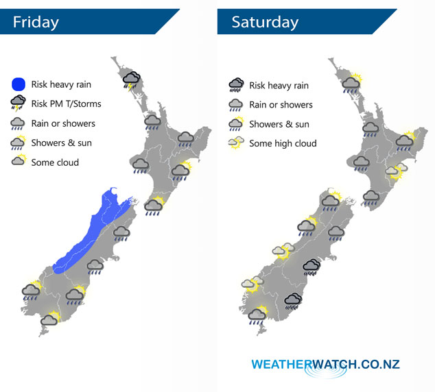
A low and combined cold front rotates onto New Zealand during today coming in from the Tasman Sea. This low doesn’t move far on Saturday driving an easterly airflow over the South Island, westerlies further north.
Wet weather for most western regions today, heavy at times for some. Perhaps even a thunderstorm in the afternoon about Northland. The eastern North Island has a dry morning then some rain spreads from the west late afternoon or evening, clearing overnight. Dry at first for the eastern South Island, the odd spit or shower from midday then rain moves in by evening.
Showers for much of Saturday about the western North Island, drier in the east. A wet day for the eastern South Island with areas of rain or showers, heavy falls possible from afternoon south of Banks Peninsula. Mainly dry for the west coast however expect a few showers north of about Hokitika especially in the morning.
By Weather Analyst Aaron Wilkinson – WeatherWatch.co.nz
Latest Video

Matariki, the long weekend + the outlook for next week
Wet weather and cloud continues along the eastern side of the country with the heaviest rain now moving into northern…
Related Articles
Matariki, the long weekend + the outlook for next week
Wet weather and cloud continues along the eastern side of the country with the heaviest rain now moving into northern…

More eastern rain, but a drier long weekend coming
Rain continues today along the eastern South Island and lower North Island, coming in from the east with heavy falls….

More heavy rain, snow – but large dry areas, especially as we go into the long weekend
Heavy rain will continue for parts of Canterbury and Marlborough over the next day or two and it will gradually…

