InfoGraphic: The Big Picture for Friday / Saturday
1/02/2018 6:00pm

> From the WeatherWatch archives
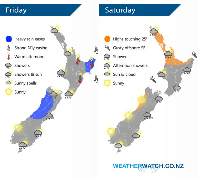
A southwesterly airflow lies over New Zealand today, a low centred just off the West Coast of the South Island eases during the day while a front over northeastern parts of the North Island clears away during this morning. A south to southwesterly airflow lies over the country on Saturday.
Morning heavy rain clears northeastern parts of the North Island, rain for the South Island may be heavy early on this morning then it quickly eases. The Bay Of Plenty should have a nice day with warm afternoon temperatures after any early rain clears, the same goes for Hawkes Bay and Gisborne.
Sunny for the west of the South Island on Saturday, the odd shower in the east Banks Peninsula northwards. Showers for the east of the North Island ease from afternoon becoming patchy, sunny spells for the west of the North Island however about the Waikato and Auckland isolated showers develop in the afternoon some possibly becoming heavy.
By Weather Analyst Aaron Wilkinson – WeatherWatch.co.nz
Latest Video

Temperature changes for some regions ahead of heavy West Coast rain
A nor-wester is about to kick in and it’s coming from out of Australia, boosting temperatures in some regions going…
Related Articles
Temperature changes for some regions ahead of heavy West Coast rain
A nor-wester is about to kick in and it’s coming from out of Australia, boosting temperatures in some regions going…

NZ 7 day forecast: Showers, temp changes and heavy West Coast rain
NZ has a fairly messy forecast over the next 7 days, but the main feature will be heavy rain on…

Cold fronts continue, wind & rain for some Fri/Sat
Wet weather is moving over the North Island today, while the South Island has drier skies – ahead of another…

