
> From the WeatherWatch archives
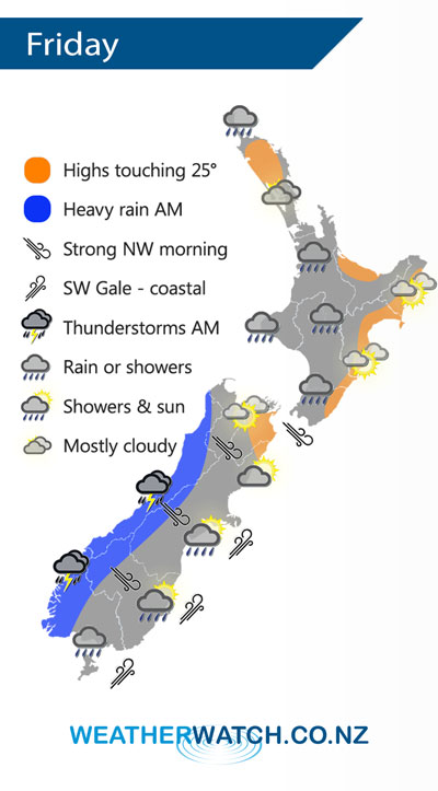
A cold front pushes northwards over New Zealand during Friday reaching the North Island in the afternoon, it will weaken as it moves northwards however. Strong northwesterlies ahead of the front then changing colder southwest in behind.
Showers for the west of the North Island Waikato southwards on Friday, clearing in the evening. Auckland may see a shower or two in the afternoon or the city may stay mainly dry with showers just to the south. Out east conditions are mainly dry however a southwest change late afternoon or evening may bring a few showers to the Wairarapa then later on for Hawkes Bay and Gisborne.
Morning heavy rain and possible thunderstorms for the West Coast of the South Island then clearing and sunny areas increasing in the afternoon. Strong northwesterly winds in the east with gales in the high country then a southwest change (coastal gales Banks Peninsula southwards) races northwards in the morning, staying mainly dry for Canterbury and Marlborough although a shower or two is possible. Morning showers for Southland could contain some small hail.
Overnight conditions becoming quite cold for the inner South Island with light frosts possible by dawn on Saturday.
By Weather Analyst Aaron Wilkinson – WeatherWatch.co.nz
Latest Video

Wintry weather coming: Snow, rain, wind & sunshine
A cold front is moving into NZ from Friday to Sunday with low pressure developing west of NZ and then…
Related Articles

Polar airflow + northern low = pockets of heavy rain & snow
A colder change is coming – and so too is a large low which will develop and grow over northern…
Wintry weather coming: Snow, rain, wind & sunshine
A cold front is moving into NZ from Friday to Sunday with low pressure developing west of NZ and then…

ClimateWatch: JULY outlook & what El Niño means for NZ
El Niño is officially here and still getting stronger in the months ahead, but it’s harder to notice its effects…

