
> From the WeatherWatch archives
Heavy rain hit Taranaki this morning causing some damage to The Radio Network building after the gutters were overwhelmed with water.
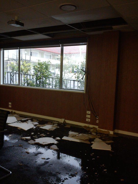
Employee Greg Taylor says the downpour caused damage to the ceiling in their boardroom, despite the building having recent renovations.
 WeatherWatch.co.nz says the downpour is a result of a slow moving rain band that has already pushed into Taranaki and Waikato and will tonight move into Auckland and Northland and further inland during Saturday.
Image – Damaged ceiling at TRN New Plymouth / Greg Taylor
The top half of the North Island is in for heavy rain tonight and tomorrow with MetService rain warnings predicting the hills between Taranaki and Waikato may receive up to 170mm.
Meanwhile a cold change is coming to Christchurch after today taking the national high of 30 degrees. It’s the second time this week the city has taken the national high, reaching 29 on Wednesday. Some are complaining the hot weather is creating stronger smelling sewage in some parts of the city.
Despite some media outlets describing it as a “wintry blast” WeatherWatch.co.nz says the city will still reach highs in the mid teens this weekend. Lows are expected to be down to 7 degrees in the CBD on Sunday night.
“This is our first Autumn storm and it’s only brushing New Zealand – the centre is well south of the country” says head weather analyst Philip Duncan. “It’s not going to be pleasant to be outdoors in Christchurch this weekend but the flip side is it will mean no dust storms and will actually help absorb some of the liquefaction back into the ground”.
Mr Duncan says people who are collecting rain water to drink should allow an hour or two of rain before drinking roof water. “The dust that’s been blown about this week contains sewage particles, so it would be wise to let the rain fall for some time before drinking anything off the roof”.
WeatherWatch.co.nz recommends people collect the water in pots and buckets that have not been exposed to this weeks dust storms.
The colder change will arrive on Saturday afternoon with Sunday and Sunday night looking to be the coldest period. Both WeatherWatch.co.nz and MetService predict a high of 16 degrees for Sunday and a low of 7 for Christchurch, more inline with Autumn than Winter.
WeatherWatch.co.nz says the cold change may spark a few thunderstorms over the South Island, most likely in Westland and Southland tomorrow, however it’s not out of the question that a couple may reach Canterbury.
You’ll find the free and live Lightning Tracker here.
– WeatherWatch.co.nz
Comments
Before you add a new comment, take note this story was published on 4 Mar 2011.
Latest Video

(VIDEO) NZ 7 Day: Variety in the weather, but Southern Ocean storms waking up
Low pressure moves in to NZ from the Tasman Sea this weekend and completely falls apart – bringing downpours and…
Related Articles
(VIDEO) NZ 7 Day: Variety in the weather, but Southern Ocean storms waking up
Low pressure moves in to NZ from the Tasman Sea this weekend and completely falls apart – bringing downpours and…

VIDEO: ClimateWatch: July is the month of BIG lows, BIG highs
This month around New Zealand, Australia and the region we see big highs and big lows – bringing decent stretches…

VIDEO: Severe weather risks for NZ as low moves in
Programming Note: Apologies but we have no video on Thursday – back again on Friday! – A storm in the…


Add new comment
sw on 4/03/2011 5:00am
Philip can you explain why the wind has changed to a general southerly(SW to SE) direction tonight and the temperatures already under the nights minimum please?Forecast NW.
Reply
WW Forecast Team on 4/03/2011 5:19am
Winds are fairly variable around the city tonight, with SE winds at the airport and Northerlies at Whenuapai. Last hour it was 19 at the airport and 24 at Whenuapai – a big difference. Clearly air off the sea is affecting the airport, where is air from the warmed land is affecting Whenuapai. Our low is 19 to 21 across the city (revised down from 20 to 21) and we think the northerlies will push back in again in the coming hours at the airport.
– WW
Reply