
> From the WeatherWatch archives
The high across Gisborne and Hawke’s Bay today is about 34 degrees – tomorrow the late teens, thanks to a southerly change.
This same southerly has already affected parts of the South Island and believe it or not overnight lows through inland Southland and Otago tonight will be closer to freezing than they will double digits. Dunedin’s high on Wednesday is just 14 degrees and it may even struggle to reach that.
A cool night tonight in the lower South Island and a cooler couple of days coming up for the sweltering east coast of the North Island.
The rest of the week looks cooler in the east but will likely warm up again to around 30 degrees by Sunday.
While the cool change for the North Island’s east coast is quite a dramatic one it’s also fairly short lived, while the lower and western South Island’s ongoing spluttering summer means more of the same below average temperatures are coming over the next 10 days. It may be the second half of February before things calm down again in the South Island.
Temperatures in the hottest part of NZ today as of 1:10pm (Tuesday)
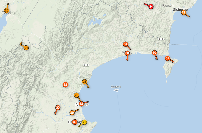
As you can see in the 1pm temperature maps below for today Tuesday and tomorrow Wednesday the south to south east wind change flushes away the hot air from much of the North Island. While Northland is still hot next couple of days it is a little cooler on Friday.
 1pm Tuesday
 1pm Wednesday
– Temperature forecast maps by Weathermap.co.nz, current observations by Wunderground’s community data network
– WeatherWatch.co.nz
Latest Video

Cold weekend, frosts return with high pressure, then a low late next week
The subantarctic airflow spreads over NZ today/tonight and into Saturday, dropping temperatures nationwide. Snow flurries are possible today to lower…
Related Articles
Cold weekend, frosts return with high pressure, then a low late next week
The subantarctic airflow spreads over NZ today/tonight and into Saturday, dropping temperatures nationwide. Snow flurries are possible today to lower…

Wintry burst of weather: Snow, squally showers then sunshine & frosts
A polar change (another one!) arrives on Friday for the South Island and goes nationwide on Saturday, leaving NZ under…

Antarctic southerly for parts of NZ Fri & Sat
For the first time this year a southerly from off Antarctica is heading towards the South Island, followed by more…

