Dry northern NZ has better chances of rain today, Canterbury too
16/12/2019 7:06pm

> From the WeatherWatch archives
Every rain cloud and rain event is as unique as a finger print which is why forecasters need to closely examine each set up and what that means for you. It’s why forecasting rain isn’t always as easy as some might think.
Not only do rain bands have a unique shape & look but every one of them – just like people – behaves slightly differently. A very slight shift in air pressure or airflows can dramatically alter the course of downpours, thunderstorms and rain bands – especially over narrow regions like Auckland, Taranaki and Northland which have sea surrounding them. Auckland is just over 1km wide at one point making tracking rain very hard as a couple kilometres difference can see it entirely falling at sea.
Downpours since the weekend have been isolated and hit and miss across the upper North Island – giving some farmers and growers real relief with some getting 25mm in just one hour. Others nearby getting less than 2mm. That is the nature of showers. Showers are hit and miss and don’t always hit where you are.
The rain coming in today is more widespread but again not overly huge. This morning we see patchy rain and showers but plenty of dry areas too. This afternoon more widespread rain should cross the upper North Island with some hit and miss heavy falls. The general estimate is most places should get 15mm today, others double or triple that in the upper half of the North Island.
Eastern Northland and eastern Coromandel Peninsula look to perhaps receive the lowest rainfall totals – although isolated downpours will give pockets of higher totals in those places too. That’s why this is a tricky event to be precise for everyone.
This rain event won’t reverse the big dry that has been forming but for some pockets it will bring some good relief at the right time – and for others it will give a great pre-Christmas boost to pasture and plant growth. But there will be a group of people who don’t get enough due to the blocking nature of our mountains and ranges.
Rain will spread into most parts of NZ for a time with Canterbury also getting some heavier rain today with varying totals across the region. It will be very welcome by many gardeners, growers and farmers after weeks of windy, warm, nor’westers which have been drying many places out.
If you need rain – all the best over the next 48 hours. Also, over the summer holidays with no weather videos here at WeatherWatch we’ll again be providing you with RainWatch – a daily weather map update on forecast rainfall totals and best chances for moisture across NZ.
FORECAST RAINFALL TOTALS ACROSS TUESDAY & WEDNESDAY: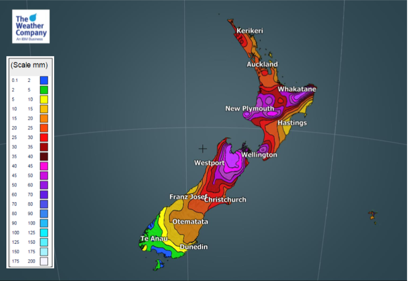
– WeatherWatch.co.nz
Latest Video

Rain & showers this weekend, colder change next week
Some places will warm up over the next day or so as a nor’wester out of Australia moves across NZ,…
Related Articles
Rain & showers this weekend, colder change next week
Some places will warm up over the next day or so as a nor’wester out of Australia moves across NZ,…

Temperature changes for some regions ahead of heavy West Coast rain
A nor-wester is about to kick in and it’s coming from out of Australia, boosting temperatures in some regions going…

NZ 7 day forecast: Showers, temp changes and heavy West Coast rain
NZ has a fairly messy forecast over the next 7 days, but the main feature will be heavy rain on…

