Departing low and incoming high = colder nights for some (+4 Maps)
19/06/2018 10:33pm

> From the WeatherWatch archives
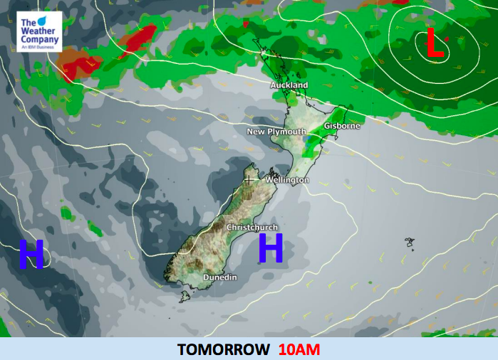
The weather pattern is a bit messy right now but high pressure is slowly building and expanding over the country and while the centre won’t spread over New Zealand any day soon the calmer weather will.
Lighter winds and clearer skies after the southerly flow for many this week will see overnight low dropping down to frost territory. Nothing too serious, but a chance of frosts across the South Island – less likely in the North Island due to continuing breezes and cloud. It’s possible inland areas of the North Island may be closer to a frost later in the week.
It’s still a bit windy over the North Island for Wednesday, nothing serious for land though.
The low north of New Zealand will continue to hang around for Thursday but moves away by Friday as high pressure expands further over the North Island, however it may encourage a sou’west flow which will bring a few showers and clouds to the western coastline.


– WeatherWatch.co.nz
Comments
Before you add a new comment, take note this story was published on 19 Jun 2018.
Latest Video

NZ VIDEO: Severe weather going into the weekend. Next week: Westerlies continue
Heavy rain and northerly gales are moving across NZ going into the weekend as a large low from the Tasman…
Related Articles
NZ VIDEO: Severe weather going into the weekend. Next week: Westerlies continue
Heavy rain and northerly gales are moving across NZ going into the weekend as a large low from the Tasman…

VIDEO: Low pressure, cold fronts, main feature next two weeks
There are several low pressure zones and cold fronts coming into NZ, with westerly driven weather dominating our weather pattern…

VIDEO: Burst of wind and rain for NZ as low pressure dominates
Air pressure around New Zealand will continue to drop in the days ahead as low pressure systems affect our weather…


Add new comment