Damaging hurricane force winds hit Dunedin, fires and heat across Canterbury Thursday (+3 Maps)
10/03/2016 6:25am

> From the WeatherWatch archives
Updated 7:25pm — Damaging winds continue to reach hurricane force in Dunedin with sustained gusts of 124km/h at the airport earlier this evening and one private weather station from a reliable source going offline with a gust to 150km/h. Trees are down, debris covers the roads, waves are crashing over some coastal roads and powercuts are spreading.
The damaging winds are peaking from late afternoon through to mid/late evening. It means it will be a very windy start to the evening – but winds will slowly ease back overnight in the city.
Further north and winds through Canterbury were gusting 90 to 100km/h in many areas earlier today, it’s eased a little this evening in some areas, but areas closer to Otago and the eastern coastline may see gales over 80km/h at times this evening.
Temperatures in the low 30s across Canterbury will be replaced by much cooler air this evening and tonight.
The hot windy weather saw more fires flare up today in Canterbury, including one in Darfield after a controlled burn off got caught up in the gales. We’re unsure why a controlled fire was lit on a day that was forecast to be 30 degrees with windy conditions forming. More flare ups at Hanmer Springs occurred too.
Wellington’s winds have dropped from over 110km/h in the city this afternoon (higher on the ranges as reported by MetService) but have eased to 70km/h gusts as of 7pm.
After thick fog this morning Hamilton and the rest of Waikato had mostly sunny weather today.
Temperatures in Hawkes Bay climbed over 30 degrees today while mostly sunny weather spread across regions like Auckland, Bay of Plenty and Northland.
WIND MAPS:
CURRENT WIND MAP – Areas in Purple indicate hurricane force (severe gale) winds.

1AM FRIDAY WIND MAP – Winds continue to ease back gradually in Dunedin and Oamaru, worse of the winds moving NE out to sea.
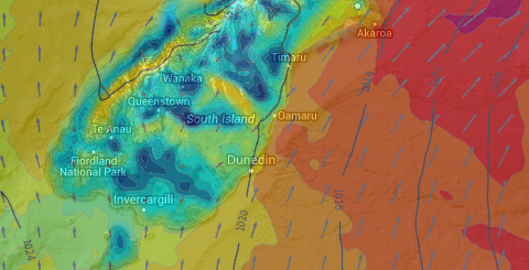
4AM FRIDAY WIND MAP – winds ease even further in Otago, also easing in most of Canterbury – although Banks Peninsula to Kaikoura may still receive gales from the SW.
– Maps by WUnderground
– WeatherWatch.co.nz
Latest Video

Wintry weather coming: Snow, rain, wind & sunshine
A cold front is moving into NZ from Friday to Sunday with low pressure developing west of NZ and then…
Related Articles

Polar airflow + northern low = pockets of heavy rain & snow
A colder change is coming – and so too is a large low which will develop and grow over northern…
Wintry weather coming: Snow, rain, wind & sunshine
A cold front is moving into NZ from Friday to Sunday with low pressure developing west of NZ and then…

ClimateWatch: JULY outlook & what El Niño means for NZ
El Niño is officially here and still getting stronger in the months ahead, but it’s harder to notice its effects…

