Brief break in the rain for some but ex-cyclone won’t cross NZ until tonight
4/04/2017 7:33pm

> From the WeatherWatch archives
Very heavy rain and downpours overnight have mostly cleared Auckland and Northland this morning, but the low remains to the west of the regions and continues to deepen and move in today. Or put another way – the rain isn’t over yet.
The dry start to the day will be welcome news to the authorities dealing with a night of issues relating to the rain in our largest city. Sunny spells are now spreading over the city – but this may add fuel to downpours later today, so it’s a bit of a complicated system and set up.
Talking to James Coleman on Radio Live earlier this morning WeatherWatch.co.nz head forecaster Philip Duncan described the rain bands as being a bit like “Swiss cheese”. Mr Duncan says there are holes in the rain clouds with dry spells, especially in Northland, Auckland and Taranaki this morning.
Rain wil return later though, with downpours again moving in later today.
Meanwhile rain is also temporarily easing in Hamilton and other parts of Waikato – but the same rain band that cleared Auckland around dawn is now moving into Coromandel Peninsula with some heavy falls along with Great Barrier Island (in the Auckland region).
The rain radar is also showing more rain out in the Tasman Sea yet to come in – so while a pause in the rain will be welcome, the situation isn’t over as the low out at sea continues to move closer to New Zealand while deepening.
Mr Duncan says the focus needs to remain on the big picture. “We can get very focused on forecast total millimetres of rain, but in reality the geography of New Zealand means rainfall totals will vary wildly within regions let alone across the country. My best advice is to stay focused on the big picture and that is that the centre of ex-cyclone Debbie will tonight and tomorrow morning cross through Cook Strait so more heavy rain is coming in, perhaps more focused around the lower North Island and upper South Island”.
“When the rain band is like Swiss cheese, with some holes in it, you tend to get fewer areas of flooding but the tropical nature of this entire system means there is generally quite a high risk of slips and flooding across about two thirds of New Zealand for about another 24 hours”.
 Rain Radar (funded by the NZ Taxpayer) shows a break in the rain for some regions (7:15am)
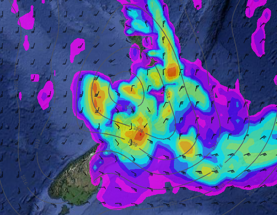 More rain coming though – here’s the forecast for 9pm Wednesday showing the centre of the low approaching Cook Strait surrounded by more heavy rain. Further north and further south conditions don’t look as wet, especially in the Deep South which may be completely dry.
– WeatherWatch.co.nz
Latest Video

Westerlies continue, sub-tropical for some
West to north-west winds blow through the South Island and lower North Island today bring heavy West Coast rain and…
Related Articles
Westerlies continue, sub-tropical for some
West to north-west winds blow through the South Island and lower North Island today bring heavy West Coast rain and…

Westerly change this week, unsettled but large dry areas
Westerlies kick back in again this week which will bring a break to those in the east as far as…

Matariki, the long weekend + the outlook for next week
Wet weather and cloud continues along the eastern side of the country with the heaviest rain now moving into northern…

