
> From the WeatherWatch archives
Large swells and waves are expected to develop along the North Island east coast this weekend as a deep low tracks south east well off shore.
The low is intense enough to drive big swells for hundreds of kilometres from the centre.
At the centre of the low swells of over 8 metres are currently being generated, according to weathermap.co.nz. By the weekend those swells will reach the eastern North Island.
Most exposed to the dangerous seas will be eastern parts of the North Island from East Cape to Wairarapa – with the Gisborne/East Cape region being most exposed.
Weathermap.co.nz predicts swells up to 3 metres could affect exposed beaches in the Gisborne / East Cape area on Monday.
WeatherWatch.co.nz predicts sunny weather with a high of around 22 to 24 degrees on Sunday in the Gisborne region – meaning more people may be at the beach and unaware of the stormy weather offshore generating dangerous rips and waves locally.
Rough seas may also spread into Hawkes Bay on Sunday.
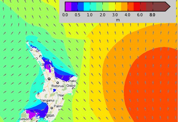
Map for 1pm Sunday shows swells of 2 to 3 metres moving in to the East Cape region.
For more detailed maps – which are zoomable – simply click the map above.
Image / weathermap.co.nz
Comments
Before you add a new comment, take note this story was published on 25 Nov 2010.
Latest Video

VIDEO: Severe weather risks for NZ as low moves in
Programming Note: Apologies but we have no video on Thursday – back again on Friday! – A storm in the…
Related Articles
VIDEO: Severe weather risks for NZ as low moves in
Programming Note: Apologies but we have no video on Thursday – back again on Friday! – A storm in the…

VIDEO: ClimateWatch: July is the month of BIG lows, BIG highs
This month around New Zealand, Australia and the region we see big highs and big lows – bringing decent stretches…

VIDEO (NZ): Large low looms – who gets rain/wind & who does not
Another large low will bring severe weather to parts of both main islands of NZ this week, followed by a…


Add new comment
Ryan on 25/11/2010 7:11am
Far out! do you reckon any of this will make it to the Bay of Plenty coast? Mount Maunganui in particualar. From what ive seen elsewhere its going to be 1/2 – 1meter.
Reply
WW Forecast Team on 25/11/2010 7:32am
BOP and the Mount are both sheltered from this low – but a new low next week will drive in 1 to 2 metre swells. The downside for surfers is that the wind will be an easterly.
– WeatherWatch
Reply
Dave on 25/11/2010 7:46am
Upside for the kitesurfers then 🙂
Reply