Aussie storm falling apart, but will bring big change to New Zealand’s weather
29/09/2016 7:40pm

> From the WeatherWatch archives
UPDATED 8:40am — The big storm that walloped South Australia is coming our way – but not as a storm. Instead the leftovers from the storm that cut the power to an entire Australian state on Wednesday will bring a significant shift in New Zealand’s weather pattern.
The shift will see an end to the week-long, grey, wet easterly flow across many northern areas and replace it with a much windier, warmer, westerly flow next week.
The leftovers from the Australian storm will arrive on Sunday in the form of heavy downpours and warm, brisk, nor’westers.
Some of these slow moving downpours may be intense enough to cause localised flooding – that means a valley might flood, not an entire region. It’s hit and miss but worthy of monitoring on Sunday in case afternoon heating adds more fuel to the downpours.
Once we get into Monday that Aussie system is falling apart but the westerly flow covering New Zealand is truly a direct Australian airflow – coming straight out of Brisbane, Sydney, Canberra, Melbourne and Adelaide and across New Zealand.
It’s late – but spring’s windy westerlies arrive next week with a big spring front crossing the country on Tuesday PM and Wednesday AM with a burst of rain, possible thunder and blustery winds.
 Yesterday (Thursday) 1pm / Big storm today over South Australia, Victoria and Tasmania
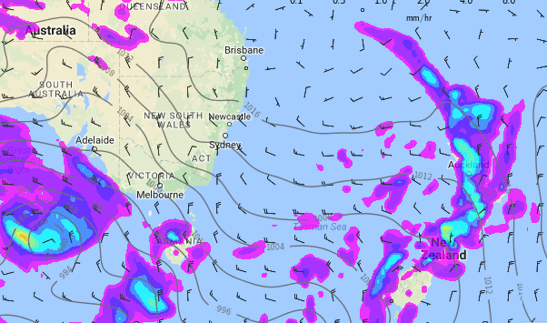 This Sunday 1pm / The low over Australia has vanished by Sunday – it’s fallen apart but the energy left over still comes at New Zealand in the form of brisk winds but perhaps most importantly localised heavy downpours in the west. Also note the new westerly airflow crossing the main centres in Australia and then crossing New Zealand.
– WeatherWatch.co.nz
Latest Video

Cold weekend, frosts return with high pressure, then a low late next week
The subantarctic airflow spreads over NZ today/tonight and into Saturday, dropping temperatures nationwide. Snow flurries are possible today to lower…
Related Articles
Cold weekend, frosts return with high pressure, then a low late next week
The subantarctic airflow spreads over NZ today/tonight and into Saturday, dropping temperatures nationwide. Snow flurries are possible today to lower…

Wintry burst of weather: Snow, squally showers then sunshine & frosts
A polar change (another one!) arrives on Friday for the South Island and goes nationwide on Saturday, leaving NZ under…

Antarctic southerly for parts of NZ Fri & Sat
For the first time this year a southerly from off Antarctica is heading towards the South Island, followed by more…

