Antarctic Snap: A detailed forecast for those most exposed next 2 days
21/06/2015 4:58am

> From the WeatherWatch archives
Monday marks the shortest day of the year in New Zealand so it’s timely that we’re about to get a shot of Antarctic air. It’s not a big snow maker – but it certainly is a significant shot of cold air from our polar part of the planet.
Below is WeatherWatch.co.nz’s detailed forecast for this cold change, snow-wise, for the country. No matter where you live in New Zealand temperatures will drop on Monday or Tuesday. It may well be sunny for many areas though, especially if you have ranges/mountains to the south.
With high pressure rolling in this week expect severe frosts for some parts of the South Island and heavy frosts into the central North Island too as winds die down and inland skies clear. Frosts below -10 are possible in places like Central Otago. So cold, rather than snow, really is the main focus with this next bit of weather.
Snow from this cold change will make it to sea level in some areas – but it’s not a major snow event due to precipitation levels being quite low. In other words, there may not be many showers worthy of making snow so it won’t be as widespread like the recent event – and it certainly won’t be as heavy. Ski fields in both islands are likely to get a little more of the white stuff though – the ski season is shaping up well this year in our view.
Last week ended warm for many – this week will not be the same. Welcome to winter – and to the start of the coldest, darkest, 8 weeks of the year.
– Philip Duncan
Detailed Cold Snap Forecast for New Zealand
– Prepared by Aaron Wilkinson 5pm Sunday:
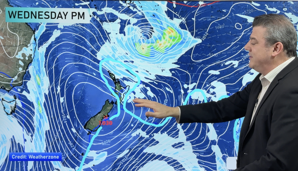
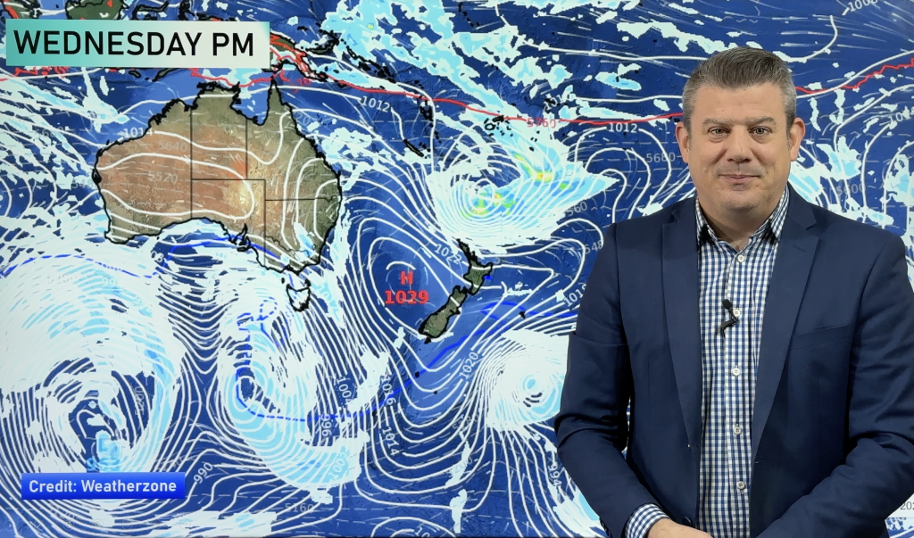
An anticyclone runs deep into the south Tasman (southern Ocean) west of New Zealand and is forcing up a very cold southerly airflow which spreads over the South Island this evening / overnight and onto the North Island on Monday.
The amounts below could vary + or – 5cm of snow, perhaps even as much as 10cm if on a hillside exposed to the prevailing SW flow etc. And there is always a chance the snow level could vary 50 to 100m versus the below quoted figures, due to our geography.
The forecasts below are for the regions most exposed to this cold polar change snow and shower-wise:
Southland:
We should have shower activity now, heavy at times with hail, then clearing overnight. Winds are strong to gale force from the west then tending more southwesterly this evening. Snow to 300m lowers to around sea level overnight then clearing, as we know Invercargill doesn’t really get sea level snow in southwesterlies so they may see nothing. 10cm to 300m, 5cm possible to 150m then minimal flurries to sea level. Shower activity backs off a fair amount before the really cold air moves in, reducing the amount of snow that will fall.
Central Otago:
Shower and small hail at times from now but clearing overnight. Snow to 300m currently, lowering to low levels overnight then clearing. 10 to 15cm to 500m, 5 to 10cm down to 400m, 5cm down to low levels.
Coastal Otago:
A few showers may have started to move in now but it doesn’t really set in till this evening. Showers could be heavy with the risk of a thunderstorm and hail then clearing before midday Monday. Snow to 300m lowers to sea level overnight. 5 to 10cm down to 300m, sea level flurries and while moisture levels aren’t very much, 1 to 3cm to sea level is possible – but it may only fall with nothing settling.
South Canterbury:
This part of Canterbury will be quite sheltered from any snow. Southwesterlies ramp up late afternoon / evening bringing a few showers which clear around midnight. Some snow to 300m may lower to sea level for a brief time by midnight but around then shower activity clears. 1 to 3cm possible to 300m, minor flurries below that level.
Mid Canterbury:
A slightly better chance for snow. Southwesterlies ramp up late this afternoon & evening. Shower activity moves in bringing a risk of hail, showers activity eases overnight but there will still be some about then clearing early afternoon on Monday. A few snow flurries to 300m this evening lowering to sea level early on Monday morning before clearing around midday. Amounts are fairly minimal, 5cm to 300m, minimal amounts to sea level but 1 to 3cm possible – however to be honest it will likely be very little or nothing – but if anything, amounts will be a little higher near the coast and lesser inland.
Christchurch (including Banks Peninsula):
Showers from evening, continuing through Monday and clearing mid to late afternoon, there might even be a straggler hanging around till evening. Showers may contain small hail at times and be heavy. Snow to 400m lowers to sea level on Monday morning. 5 or perhaps 10cm at the very most to 400m, 1 to 3cm down to sea level. Because Christchurch juts out a little more into the southwest flow, then say Timaru, does Christchurch should in theory pick up more shower activity and yes indeed some snow – it won’t be much, but it’s something to pin your hopes on! The main difference with Banks Peninsula is winds will be stronger, expect strong southwesterly winds gusting to gale at times over the Peninsula.
North Canterbury (north of Amberley through to Kaikoura etc): Showers move in from this evening (perhaps late evening), showers may be heavy at times and contain hail then clearing tomorrow evening. Snow to 300m this evening then lowering to sea level or near sea level tomorrow morning. 5 to 10cm down to 300m, 1 to 3cm possible down to sea level, or near sea level at least.
Marlborough: Due to Marlborough being quite sheltered in a SW flow not much will happen. A few showers pass through around midnight more or less then clear. A couple of centimetres of snow possible to about 400m.
Wellington, Wairarapa: Shower activity moves in around midnight tonight with strong southerly winds, a chance showers could be heavy with hail initially then backing off a bit overnight, showers still continue on and off during much of Monday finally clear early on Tuesday. Snow flurries to 400m at first lowering to near sea level Monday afternoon from then onwards. You have to remember that the near sea level snow will more then likely just be the odd flurry and not settle, the air is certainly cold looking but shower activity is fairly minimal. 1 to 3cm possible to 400m, minimal flurries below that level. Wairarapa will be very similar to Wellington.
Central North Island (Desert road etc):
Isolated shower activity mainly from overnight tonight, backing off by midday Monday then mostly clearing by midnight. Snow to 700m lowers to about 300 or perhaps even 200m by tomorrow evening. 5 to 10cm possible to 700m, 3 to 5cm possible to 300m and minimal amounts any lower. Snow totals lower down aren’t going to be high nor will they be widespread – but the Desert Road may have enough to be closed.
Hawkes Bay – mountains/ranges mostly
Showers move in overnight or perhaps towards dawn Monday as a southwest change pushes in. There looks to be an initial burst of shower activity on the change but then it mostly clears away, not really pushing back in till overnight Tuesday but even then shower activity isn’t all that much. Showers clear around midnight on Tuesday. Snow to 700m with the change initially then lowering to near sea level overnight Tuesday. 5 to 10cm possible to 700m, 3 to 5cm possible to 300m, 1 to 3cm down to lower levels and will unlikely settle. The Napier Taupo Highway may well be affected by some snow.
– WeatherWatch.co.nz
Comments
Before you add a new comment, take note this story was published on 21 Jun 2015.


Add new comment
Guest on 21/06/2015 8:14pm
Do you think Pahiatua will get some snow?
Reply
Jacob on 21/06/2015 10:10am
Hi there, i live round the coastal hills about 100 meters in elevation in Hawkes Bay, what can i expect due to snow?
Reply
WW Forecast Team on 21/06/2015 1:35pm
Hi there
What we mention in the article for Hawkes Bay applies to you 🙂
WW
Reply
Trav on 21/06/2015 9:19am
Hi all, how do you determine what level snow will fall to?
Cheers to all
at WeatherWatch.
Reply
WW Forecast Team on 21/06/2015 1:39pm
Hi there
Snow levels can be difficuilt especially when it comes to warm advection and evaporative cooling scenarios. But in this case it’s just a case of good old really cold air. So this time around we monitor temperatures about 1500m up in the atmosphere and see where they are at to determine the snow level.
WW
Reply
William on 21/06/2015 6:51am
What an amazing and detailed article. Thank you so much.
Awesome to have such a dedicated team !!
Reply