Above normal temperatures coming by day, but cooler by night (+6 Maps)
25/08/2018 5:46am

> From the WeatherWatch archives
A cooler south to south west flow is being felt across New Zealand today and is dragging in clouds to a few of our main centres and regions. Winds are a little breezy and cool with the odd isolated shower in the western North Island and few around western and eastern sides of the upper South Island.
Believe it or not, daytime temperatures are on the rise in most areas. Saturday is cold for some, but starting on Sunday and kicking in even more on Monday temperatures will lift for most places as the high pressure system starts to shift eastwards bringing in more of a northerly flow for New Zealand.
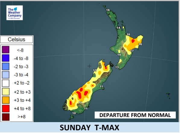
Maximum temperatures equal to normal values for September and October are forecast in some regions for the final weekend of winter. There are some big jumps in temperature coming. Inland parts of Canterbury may only have single digit highs today, but on Sunday they may reach 17 or 18 degrees. Nelson and Marlborough will climb into the late teens.
These high late teen (and possible low 20) temperatures will peak in the South Island on Monday and in the North Island on Monday and Tuesday.
But it’s not all warming up – overnight lows will be close to or below normal for most areas, especially in the North Island, caused by the cool fading south to south west flow and fairly clear skies due to the high pressure system letting that daytime heat escape at night. With calm wind and little cloud cover the risk of frost exists where minimum temperature are below 3C tonight. Frosts look light for those who may be in the risk zone though.
The temperature contrast between day and night is larger than normal for most areas for a few days
ahead.


– WeatherWatch.co.nz
Latest Video

Cold weekend, frosts return with high pressure, then a low late next week
The subantarctic airflow spreads over NZ today/tonight and into Saturday, dropping temperatures nationwide. Snow flurries are possible today to lower…
Related Articles
Cold weekend, frosts return with high pressure, then a low late next week
The subantarctic airflow spreads over NZ today/tonight and into Saturday, dropping temperatures nationwide. Snow flurries are possible today to lower…

Wintry burst of weather: Snow, squally showers then sunshine & frosts
A polar change (another one!) arrives on Friday for the South Island and goes nationwide on Saturday, leaving NZ under…

Antarctic southerly for parts of NZ Fri & Sat
For the first time this year a southerly from off Antarctica is heading towards the South Island, followed by more…

