Weather Forecast for New Plymouth28m above sea level
Thundershowers. Fairly breezy Northerly winds.
Now
Today
Tonight
Next 24 Hours in New Plymouth
Next 9 Days in New Plymouth
Day
Night
48km/h
chance
of rain
5.8mm
Day
Night
39km/h
chance
of rain
trace
Day
Night
26km/h
chance
of rain
trace
Day
Night
17km/h
chance
of rain
trace
Day
Night
16km/h
chance
of rain
trace
Day
Night
19km/h
chance
of rain
trace
Day
Night
21km/h
chance
of rain
0.8mm
Day
Night
22km/h
chance
of rain
9.3mm
Day
Night
20km/h
chance
of rain
0.8mm
Comments
If you have any questions about functionality of our website(s) or app, trying to locate maps or data, or have a simple comment/feedback - please post a comment below!
As of 2024 we will no longer be publishing questions related to weather forecasts if they are answered via our hyper-local hourly & 10 day forecasts, weather maps and regular daily and monthly weather & climate videos.
We’re a small NZ business with limited resources to respond to general weather questions. Our social media pages may be helpful to you, especially if you want to often talk (or groan!) about your local weather. You can find more resources from us here if that’s your thing.
Have questions of a commercial nature? Contact us directly here.
Thanks for your support!
Don’t forget to check out our RuralWeather.co.nz website (great for event planning or attending + camping!) and also, our brand new Weather Alerting App!
Latest Video
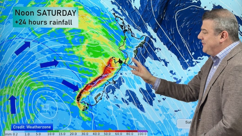
Large low = chopping & changing forecasts next several days
Expect weather forecasts to shift around a bit over the weekend and across next week in some regions as a…


Add new comment
Christine on 18/04/2026 11:45pm
Why does your weather forecast often differ from Met Service.? Very confusing.
Reply
Jet on 14/04/2026 11:03pm
Hi weather watch earlier today I checked the forecast for nelson for Sunday and said thunderstorms now it says rain is there any reason why ?
Reply
John on 14/04/2026 4:12am
Hi, do you offer soil temperature by district? Particularly useful in rural weather this time of year and spring
Reply
WW Forecast Team on 14/04/2026 9:37pm
Hi John, no sorry we don’t have that data (all historical data in NZ is owned by Niwa/MetService and they don’t share this data easily). However some local councils do have good free information on current soil temperatures, but that soil data varies from council to council. The NZ Government treats current/historic weather data as something they can leverage to commercialise, unlike most other modern nations where this data is all freely available for public good, and is designed by Govt to keep Niwa/MetService more commercially relevant and to limit fair competition (like us) from being too successful.
Cheers
– Phil D
Reply
neil on 11/04/2026 8:18pm
All other forecasters were predicting westerly wind for Saturday youre the only one predicting the SE we got.
Reply
Kathy on 11/04/2026 7:17am
Great website for current weather – not sure there are any others as good
Reply
Bruce on 11/04/2026 12:00am
Under Maps and Radar > Wind > MajicWeather Wind Forecast. The colour is based on the surface (2m) temperature, and varies from dark blue below freezing, up to green at around 10-15°c, yellow around 25-30°c and red at about 40°c.
Am I correct in assuming that the light colour (white) between the green and yellow is approximate temperature of around 16-24, or is it just light yellow?
Reply
WW Forecast Team on 11/04/2026 4:10am
Hi Bruce, the white (brightness) areas represent the strength of the wind, being severe gale and above – not the temperature. Hope that helps.
Cheers
– WW
Reply
Abigail on 10/04/2026 3:25am
Hi Phil and team WeatherWatch!
Always love and appreciate your work and your informative and calm forecasts.
Quick q about the rain totals for Auckland broken down hourly – the break down is done from 7am-6am but the overall total is done by the day – so Saturday 11 April has a very high rain total but when you break it down by hour the worst of it kicks off from about 1am onwards which technically informs the total for the day, for Sunday 12 April.
So at first glance Saturday’s total rain total for the day looks worse than Sunday’s….until you break it down by hour.
Also do you expect these totals to change tomorrow as they have been mostly consistent-ish for the last few days based on the modelling I assume?
Thanks,
Abigail
Just wondering if this is intentional?
Reply
WW Forecast Team on 10/04/2026 11:32am
Hi Abigail, thanks for your message. The way we receive the data comes in 12 hour blocks so there is basically a daytime rainfall and a nightime rainfall, so rain that is coming in overnight can show up in the prior day’s rainfall total. In our app and at RuralWeather.co.nz you can better see the rainfall in graph form so that it’s much clearer as to when that rain will fall, and how heavy it will be.
As for the totals to change – yes – because the centre of this cyclone is coming in near Auckland the precise tracking of that centre matters a lot at working out heaviest rain and strongest winds. Cyclones can wobble left and right and that may shift the future tracking, and therefore your rainfall. Our data updates each hour, so worth keeping an eye on. MetService warnings cover what is possible though and as with any rainband if it slows down the forecast rainfall totals will increase, if the storm moves faster that will decrease rainfall. Quite a few moving parts to it all!
– WW
Reply
View more comments