Yes more rain is coming, but we’re also seeing a drying trend as we head into October
25/09/2017 10:00pm

> From the WeatherWatch archives
You may need to squint your eyes a bit but if you’re looking at the models and data you’ll notice that many parts of New Zealand are entering into a slightly drier pattern as we head into October.
Clearly rain is still in the forecast – we have a number of lows and fronts around New Zealand or directly crossing the country in the next week or two, however high pressure and windy, dry, days are also showing a bit of an up-tick.
This Wednesday and Thursday a high north of New Zealand will briefly settle things down a bit after the front that is moving up the country today moves east tomorrow.
Friday says another front – and it’s fairly weak as it moves into the North Island.
On Sunday more rain and another low affects New Zealand.
But a really big high from Australia next week will also help encourage more dry weather in the north and east – and in the west for a time too. While in between rainmakers in New Zealand the windy westerlies will help dry things out, especially inland and to the east.
It’s not good news for everyone – quite possibly regions like Taranaki are in less of an ideal set up with a wetter than average forecast for them over the next week or two, although not as wet as it has been. This will affect surrounding regions too. However the general theme is that the next 10 days around New Zealand show some signs of drier rather than wetter.
The nationwide soil moisture maps are also showing hints that some regions are drying out – even if just slightly compared to where they were in winter.
Below is the outlook for New Zealand for the next week rainwise:
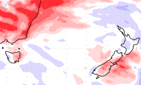
– 7 day rainfall outlook – red means drier than average, blue wetter than average, white = average / US Government
– WeatherWatch.co.nz
Latest Video

Wintry weather coming: Snow, rain, wind & sunshine
A cold front is moving into NZ from Friday to Sunday with low pressure developing west of NZ and then…
Related Articles

Polar airflow + northern low = pockets of heavy rain & snow
A colder change is coming – and so too is a large low which will develop and grow over northern…
Wintry weather coming: Snow, rain, wind & sunshine
A cold front is moving into NZ from Friday to Sunday with low pressure developing west of NZ and then…

ClimateWatch: JULY outlook & what El Niño means for NZ
El Niño is officially here and still getting stronger in the months ahead, but it’s harder to notice its effects…

