> From the WeatherWatch archives
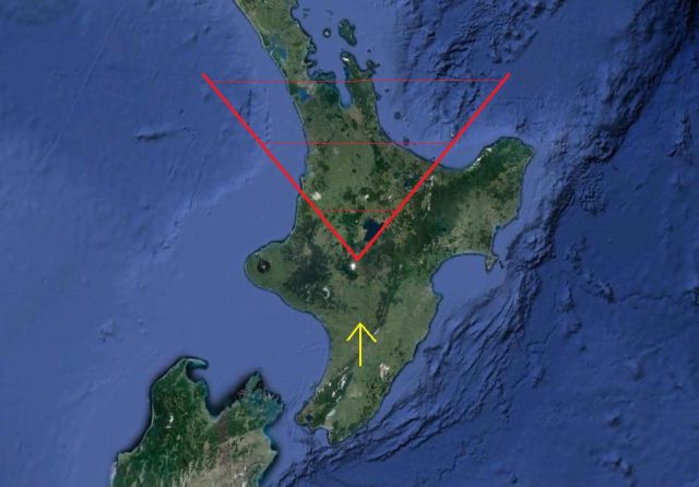
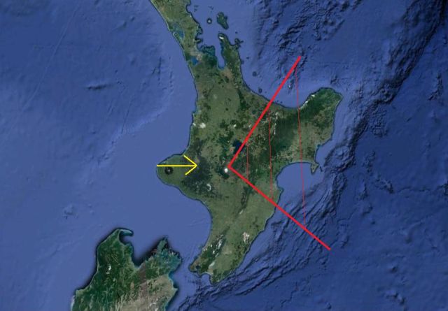
Ash from Mt Tongariro has fallen across Hawkes Bay caught up in a light nor’west flow this morning. WeatherWatch.co.nz has made 4 basic maps to show you which regions will be affected by various wind directions.
Remember – ash is not dust, it is actually powdered rock and is incredibly harsh on surfaces. Wash cars with hoses and remember it’s fine rock particles on your windscreens too (like extremely fine sand paper).
Those who rely on rain water for drinking should disconnect pipes immediately if ash has already fallen oven you. If ash has not fallen, keep up to date with the latest wind directions and should there be further eruptions it is strongly advised that you disconnect your rain water tanks if ash may fall over your place.
Want to work out wind directions for the next few days? Click here to use our interactive wind maps
MAPS
The following maps can be used as a basic guide for potential ash cloud flows should there be ongoing eruptions. These are simply risk zones for each wind direction scenario.
The red area is the risk zone for ash. The yellow arrow points the same direction as the wind is travelling.
Each wind direction takes into account the varying degrees of wind – ie, North’westers, Northerlies and Nor’easters.
NORTHERLY QUARTER WINDS
EASTERLY QUARTER WINDS
SOUTHERLY QUARTER
WESTERLY QUARTER
PREDICTED WIND FLOW FOR COMING DAYS (please note we have the centre of a large low crossing over central North Island this week so wind directions may change as the centre passes over – however winds in the centre are mostly light which should reduce how far any further heavy ash my travel.
- Tuesday: Light north to north west wind
- Wednesday: Light north to north west wind
- Thursday: Light west to south west flow
- Friday: Light variable winds
– (c) WeatherWatch.co.nz
Comments
Before you add a new comment, take note this story was published on 7 Aug 2012.


Add new comment
Guest on 7/08/2012 10:13am
Smells like Rotorua here in Palmy
Reply
Guest on 8/08/2012 2:26am
Its the same in feilding and it really was strong last night.. also just light dust n the swimming pool covers
Reply