Warmer than average start to the week, ends on a cool note (+2Maps)
29/07/2018 10:44pm

> From the WeatherWatch archives
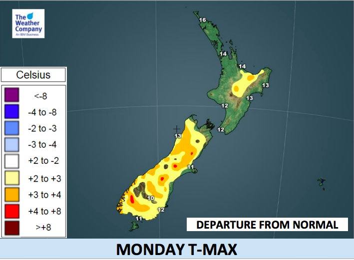
Monday will be a mostly sunny day countrywide, thanks to the large high pressure ridge spreading south. It will be short lived – tomorrow sees heavy rain return to the West Coast and windier northerlies developing across New Zealand.
Rain on West Coast will begin by Monday night and persist through Tuesday night. The total rain during Monday night and Tuesday daytime will reach around 60 mm. Higher up and heavy snow accumulation is possible over the Southern Alps on Tuesday.
The area of showery/patchy rain will move to the western part of the North Island with less intensity by Tuesday night. Rain is not likely to penetrate the eastern side of the South Island to any significant degree but a few spits are possible.
On Tuesday &/or Wednesday Marlborough, Canterbury, and Otago will be sunny and significantly warmer than usual. Max temperature in Christchurch on Wednesday will be 17C, which is 6C higher than today.
The mild weather lasts until Thursday and Friday when a cool down occurs thanks to a southerly injection. We first mentioned this last week, since then the models have eased back on this southerly and no longer does it pose as a “polar” snap, but certainly a temperature drop back to normal, or even slightly below normal in some pockets by Friday.

Latest Video

NZ: 8 Day outlook as gales & rain ease, high pressure builds
Damaging wind gusts and heavy rain will continue to affect some parts of the North Island and brushing Marlborough today…
Related Articles
NZ: 8 Day outlook as gales & rain ease, high pressure builds
Damaging wind gusts and heavy rain will continue to affect some parts of the North Island and brushing Marlborough today…

Pockets of hit & miss heavy rain, snow moves northwards
Low pressure continues to slowly move across the upper North Island and for some that will bring the sun out,…

Slow go for northern low & southern cold
For the next few days low pressure will crawl over the upper North Island, driving in rain as far south…

