The winds continue – The Big Picture on Wednesday
19/07/2016 10:48am

> From the WeatherWatch archives
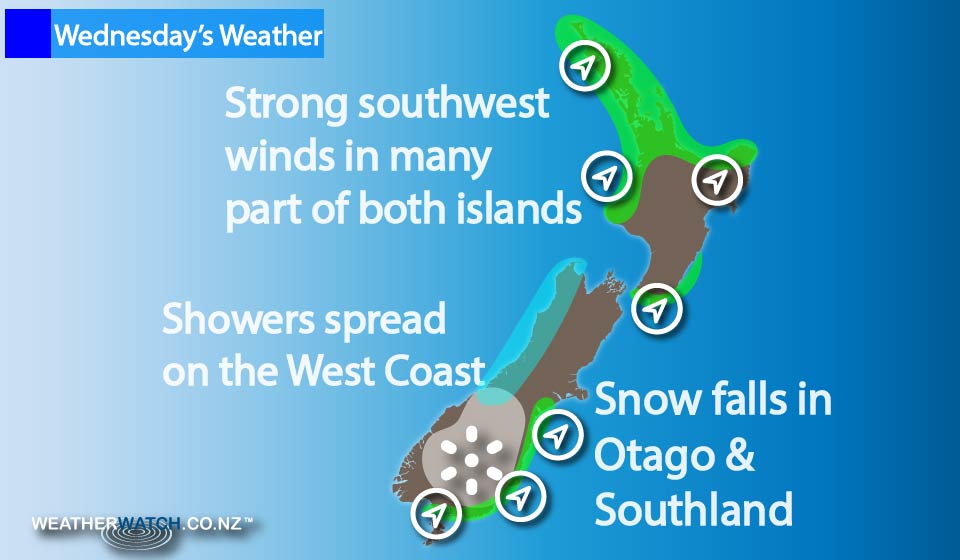
A strong southwesterly airflow sticks around through the midweek, keeping gusty and blustery winds blowing – possibly rising strongly in some areas as they have so far this week.
The winds will be felt mostly about southern and western parts of New Zealand.
Areas of cloud and the odd shower ease across the North Island during the day.
The Bay Of Plenty is mainly dry for much of the day, and so is Wellington, though there’s a chance of an early clearing shower in the capital.
Any early cloud and showers clear the east of the South Island, then sunny weather moves in with some light winds too.
Southwesterlies push into Southland from late afternoon, into Otago during the evening, and then Canterbury later at night.
For Southland and Otago, showers move through with the southwest change, bringing snow flurries down to 400m and 500m respectively.
Canterbury stays dry, with only the chance of a coastal shower as the change moves through.
The West Coast of the South Island sees areas of cloud and the odd shower with southwest winds, while rain moves in to Fiordland in the evening, and perhaps further north for a time.
– Aaron Wilkinson & Drew Chappell, WeatherWatch.co.nz
Comments
Latest Video

Wintry weather coming: Snow, rain, wind & sunshine
A cold front is moving into NZ from Friday to Sunday with low pressure developing west of NZ and then…
Related Articles

Polar airflow + northern low = pockets of heavy rain & snow
A colder change is coming – and so too is a large low which will develop and grow over northern…
Wintry weather coming: Snow, rain, wind & sunshine
A cold front is moving into NZ from Friday to Sunday with low pressure developing west of NZ and then…

ClimateWatch: JULY outlook & what El Niño means for NZ
El Niño is officially here and still getting stronger in the months ahead, but it’s harder to notice its effects…


Zelda Wynn on 19/07/2016 7:03am
Following our West Auckland beautiful red sunset; the winds are increasing as forecast. Hopefully a lovely day tomorrow!