
> From the WeatherWatch archives
Mainly unsettled today due to a low over the North Island combined with a cool southerly airflow however conditions starts to ease in the far south as a ridge moves in. Still a little unsettled on Tuesday for the North Island, calmer for the South Island although not for long as a front pushes onto the far south around midday then moves northwards.
Showers for most of the North Island and upper South Island today, showers in the west about western Auckland through to Taranaki may become heavy this afternoon then easing later in the evening. A few pockets of rain about the upper South Island may be persistent for a time also then easing this evening. Winds generally fairly cool from the south however expect northeast winds for the upper North Island, tending southerly there in the evening.
The lower South Island sees morning showers about Southland and Otago clear then sunny areas increase, mainly sunny weather on the West Coast south of Hokitika.
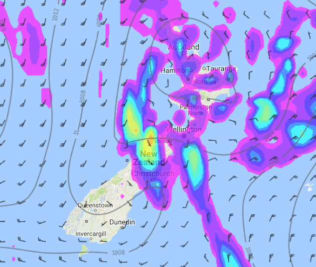
Monday 30th April 2018 3:00pm MSLP / Rain map – weathermap.co.nz
Areas of cloud and occasional sun for the upper North Island on Tuesday, a few showers about also especially in the afternoon then clearing in the evening. Mostly cloudy along the east coast with morning showers clearing, overnight a few patchy showers may move in again. Early showers clear in the west then sunny areas develop in the afternoon.
For the South Island conditions are mainly settled, some morning cloud about the upper South Island breaks away. Around midday a fresh southwest change moves into Southland bringing a few showers, pushing northwards reaching Canterbury in the evening.

Tuesday 01st May 2018 3:00pm MSLP / Rain map – weathermap.co.nz
WeatherWatch.co.nz
Latest Video

Wintry weather coming: Snow, rain, wind & sunshine
A cold front is moving into NZ from Friday to Sunday with low pressure developing west of NZ and then…
Related Articles
Wintry weather coming: Snow, rain, wind & sunshine
A cold front is moving into NZ from Friday to Sunday with low pressure developing west of NZ and then…

ClimateWatch: JULY outlook & what El Niño means for NZ
El Niño is officially here and still getting stronger in the months ahead, but it’s harder to notice its effects…

Low pressure heading to NZ this weekend & into next week
Many regions have settled weather at the moment with frosts as far north as Auckland this morning, but still some…

