Some rain relief this Friday/Saturday – but unlikely to be enough for everyone (x4 Rainfall Maps)
4/03/2019 10:05pm

High pressure continues to dominate NZ’s weather but we are seeing hints at some rain chances this coming Friday and Saturday. As the current high departs New Zealand late week – and before the next high arrives – a small area of low pressure will form.
This new area of low pressure won’t be big or very deep but it looks to be just enough to spark some rain clouds and produce isolated pockets of helpful rain – linked up by lighter, drizzly less-helpful falls.
The jury is out on just how much will fall and where – but the various models we trust are starting to firm up a little more.
At this stage it appears Friday sees the best consolidation of rain clouds producing the best chances of soaking rains here and there. Even within regions it’s a bit hit and miss though. On Saturday the rain weakens and eases. Not everyone will get relief – if you look closely at the rainfall maps you can see large areas with the blue/green shading, this indicates just 0.2mm to 20mm.
RAINFALL MAPS SHOWING TOTAL EXPECTED ACCUMULATION BETWEEN NOON TODAY (TUESDAY) AND MIDNIGHT THIS SUNDAY
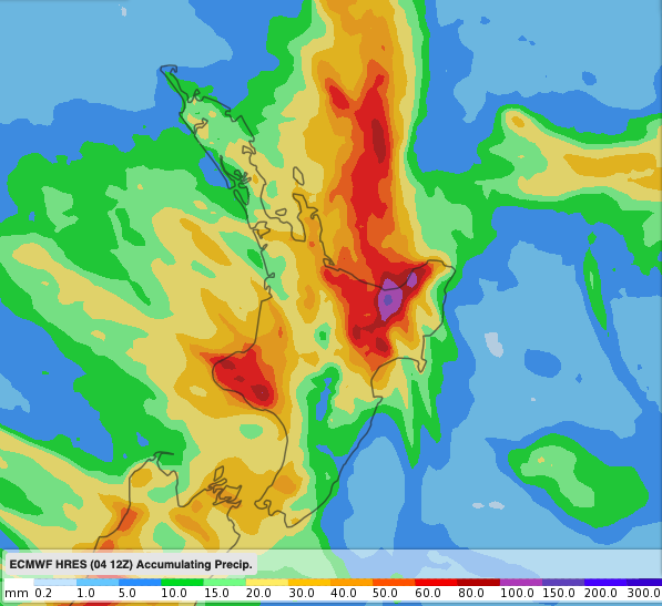 ABOVE – ECMWF (Europe)
BELOW – GFS (US Government)

ABOVE – ECMWF (Europe)
BELOW – GFS (US Government)
– WeatherWatch.co.nz
Comments
Latest Video

Weekend Newsfeed: Warmer than average ahead of large low next week(+6 Maps)
Next week subtropical and subantarctic airflows will meet over NZ – and the forecast is still yet to be locked…
Related Articles
Weekend Newsfeed: Warmer than average ahead of large low next week(+6 Maps)
Next week subtropical and subantarctic airflows will meet over NZ – and the forecast is still yet to be locked…

VIDEO: NZ’s weather for the rest of July as large low looms again
High pressure and warm nor’westers are the theme of July’s final weekend – and the final week looks to be…

Thursday Newsfeed: High pressure moves closer to NI
High pressure over the Tasman Sea moves closer to the North Island encouraging milder nor’westers from Australia into the South…


Add new comment