Showers for north eastern NZ, heavy rain for south western NZ (+4 Maps)
18/03/2018 9:00pm

> From the WeatherWatch archives
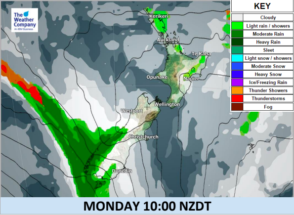
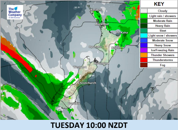
A well-marked cold front from the Southern Ocean lies over Fiordland, bringing persistent rainfall. Rainfall rates in Fiordland and southern Westland will be about 10-20mm/h Monday and into Tuesday morning,
increasing to 20-30mm/h by Tuesday afternoon and evening.
Continuous frontal rain will cause significant accumulation in Fiordland and southern Westland until Wednesday.
In Fiordland it may exceed 200mm in total during next 48 hours.
Canterbury and Marlborough will be mostly sunny until Tuesday with warmer than usual daytime
temperatures. Downslope winds crossing the Southern Alps may bring hot and dry air to some areas.
Easterlies continue in northern New Zealand, windy in some exposed places. There are a few showers caught up in this flow.
**Please note, we have no weather video today – they return on Wednesday**


– WeatherWatch.co.nz
Comments
Before you add a new comment, take note this story was published on 18 Mar 2018.
Latest Video

NZ VIDEO: Big frosts as high pressure flirts with NZ
A low will cross the North Island on Thursday while heavy frosts (-5C and below!) will affect inland parts of…
Related Articles
NZ VIDEO: Big frosts as high pressure flirts with NZ
A low will cross the North Island on Thursday while heavy frosts (-5C and below!) will affect inland parts of…

NZ VIDEO: More lows, but a reduction in severe weather
More low pressure is coming in to New Zealand this week – but rainfall isn’t as dramatic as previous weeks,…

NZ VIDEO: Westerlies, lows, showers & large dry areas
Messy westerly driven weather will affect NZ this week, bringing more wet weather to western and northern parts of the…


Add new comment