
> From the WeatherWatch archives
The crown forecster has this afternoon issued a severe thunderstorm watch for Taupo and Rotorua as afternoon heating kicks in.
The live Lightning Tracker, provided by weather enthusiasts and available to view for free here, shows little activity as of 2:30pm however it has detected a handful of lightning strikes over the past hour over land.
MetService forecaster Ian Miller says showers in parts of Bay of Plenty and Taupo are forecast to become heavier and more frequent, and isolated thunderstorms are forecast from late afternoon.
“This watch is for the possibility of a few severe thunderstorms with localised downpours of 25 to 40mm per hour in western Bay of Plenty, Taupo (mainly north and east of the lake) and Waikato near the Kaimai Range, from about 4pm until about 9pm today, Saturday”.
The crown forecaster says rainfall of this intensity can cause flash flooding, especially about low-lying areas such as streams, rivers or narrow valleys, and may also lead to slips. Driving conditions will also be hazardous with surface flooding and poor visibility in heavy rain.
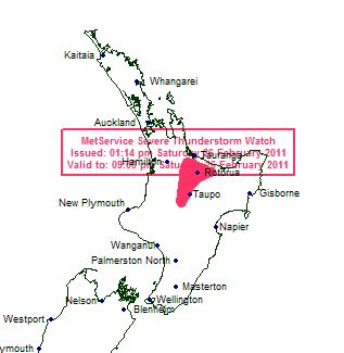
Graphic / NZ Govt
Comments
Latest Video
A few showers, but still a lot of high pressure
Showers continue in parts of NZ going into the weekend and through next week, we track them for you –…
Related Articles
A few showers, but still a lot of high pressure
Showers continue in parts of NZ going into the weekend and through next week, we track them for you –…
High pressure still in charge, but a few changes in the mix
High pressure continues to control much of New Zealand’s weather although there will be some wind and temperature changes in…
Heavy West Coast rain, a few showers elsewhere
High pressure looks to remain mostly in charge of NZ’s weather until the middle of next week when a potential…


Guest on 26/02/2011 7:12am
Currently got lightning and thunder in Papamoa Hills.