
> From the WeatherWatch archives
A large anticyclone brings mainly settled and hot weather to New Zealand again on Monday, a northwest airflow gradually builds over the South Island during the day.
For the North Island expect mostly sunny weather, some high cloud for the upper North Island in the morning slowly breaks away. Winds are from the west or southwest in the west and tend easterly in the afternoon along the east coast. There may be some mid level cloud about Kapiti during the day.
Cloud breaks to sunny spells in the afternoon for the West Coast of the South Island, cloud thickening up again in the evening about South Westland with drizzle moving in then turning to rain about Fiordland overnight. Mostly sunny for the east coast, some high cloud at times south of about Banks Peninsula. Winds are from the north or northwest, tending northeast in the afternoon along the east coast.
Another hot day in store with temperatures reaching into the mid to high twenties for most in the North Island, some places right on the coast may stick to the early twenties due to onshore winds. Conversely some places away from onshore winds warm up quite well, possibly touching or getting near thirty degrees, these spots being Bay Of Plenty and perhaps inland parts of Hawkes Bay / Gisborne.
The South Island has highs in the mid to late twenties from Southland up through to Nelson in the east, parts of Marlborough may touch thirty. The West Coast south of Greymouth has temperatures in the mid to high teens.
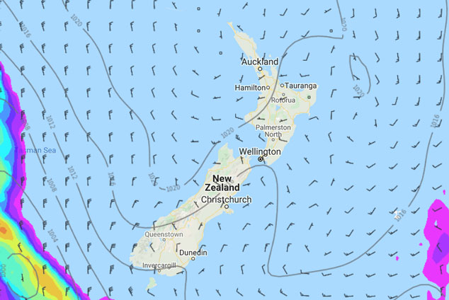
Image: Monday 4th November 2019 1:00pm MSLP / rain map – weathermap.co.nz
By Weather Analyst Aaron Wilkinson – WeatherWatch.co.nz
Latest Video

Matariki, the long weekend + the outlook for next week
Wet weather and cloud continues along the eastern side of the country with the heaviest rain now moving into northern…
Related Articles
Matariki, the long weekend + the outlook for next week
Wet weather and cloud continues along the eastern side of the country with the heaviest rain now moving into northern…

More eastern rain, but a drier long weekend coming
Rain continues today along the eastern South Island and lower North Island, coming in from the east with heavy falls….

More heavy rain, snow – but large dry areas, especially as we go into the long weekend
Heavy rain will continue for parts of Canterbury and Marlborough over the next day or two and it will gradually…

