
> From the WeatherWatch archives
The crown forecaster has this morning stepped up their prediction of thunderstorms for some parts of the upper North Island later this afternoon or evening.
They say a shallow trough lies from from Bay of Plenty to southern Coromandel Peninsula,Taupo and eastern Waikato. “The combination of humid air at low levels and cooling aloft means there is a moderate to high risk of thunderstorms for these areas during the afternoon and evening, and possibly into the night nearer the coast” the crown forecaster says.
“These thunderstorms could produce localised heavy rain up to 25mm per hour as well as hail up to 15mm in diameter”.
However in Bay of Plenty and Taupo, where any thunderstorms are likely to be very slow moving, there is a moderate risk that a few could be severe with downpours 25 to 40mm per hour.
They says there is a lower risk of thunderstorms in the immediate surrounding areas, as indicated on the chart below.
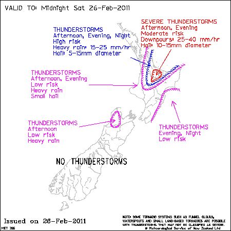
Image / NZ Govt
Comments
Latest Video
A few showers, but still a lot of high pressure
Showers continue in parts of NZ going into the weekend and through next week, we track them for you –…
Related Articles
A few showers, but still a lot of high pressure
Showers continue in parts of NZ going into the weekend and through next week, we track them for you –…
High pressure still in charge, but a few changes in the mix
High pressure continues to control much of New Zealand’s weather although there will be some wind and temperature changes in…
Heavy West Coast rain, a few showers elsewhere
High pressure looks to remain mostly in charge of NZ’s weather until the middle of next week when a potential…


didi on 26/02/2011 9:35am
I always think when you say upper north Island you mean northland wont you say central north Island for those places confusing really
Gina on 26/02/2011 2:50am
Does that mean thunderstorms for Northland?
WW Forecast Team on 26/02/2011 4:08am
No Gina, only Central Plateau/inland BOP region at this stage.
Cheers
– WeatherWatch