
> From the WeatherWatch archives
There are a couple of times of year – around now and again in half a year from now – when many of the world’s most populated areas seem to share similar conditions.
Obviously in late December the days are at their longest in the Southern Hemisphere as summer kicks off, while dark cold winter months set in across the north of the globe.
But it’s the transition months in between – the springs and autumns – that share similar weather worldwide in many of the nations we connect with frequently (obviously with execption of the tropics boundary, which is hot all year round!)
This morning WeatherWatch.co.nz put up a current map of global temperatures – some readers noted how similar New Zealand and the UK looked temperature-wise.
While nights in the UK are longer than the days now, the remnants of summers heat helps keep temperatures up. A bit like how the remnants of winter continue to pull our temperatures down whenever a southerly visits (next 12 to 24 hours in the deep south of New Zealand, for example).
Meanwhile, over in North America look at winter coming in! This classic November set up shows colder arctic air over Canada tumbling down into central parts of the USA right now. This Fall Front, for them, will bring gusts over 100km/h, and the mix of hot and cold air over such a large landmass means there will likey be tornados too, along with some flooding over the next day or two.
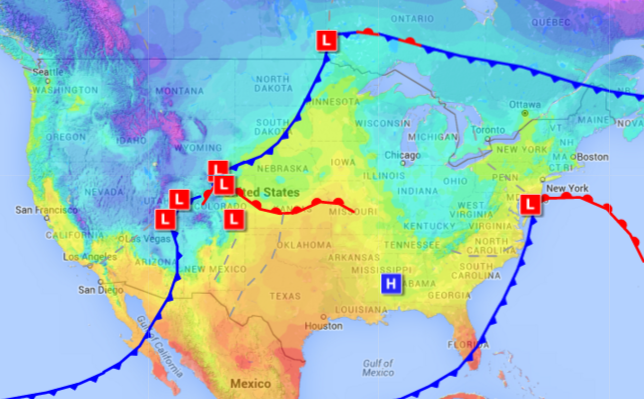 INCOMING! Middle parts of USA are about to be hit by a classic Autumn front, sweeping in cold from arctic Canada producing turbulent and sometimes violent weather as it mixes with warm air from the Gulf of Mexico south of the front / Image Credit: Wunderground
– WeatherWatch.co.nz
Comments
Before you add a new comment, take note this story was published on 11 Nov 2015.
Latest Video
NZ 8 day outlook as high pressure moves through
High pressure will cross the South Island this weekend bringing light winds, cold nights, frosts and fog, while the North…
Related Articles
NZ 8 day outlook as high pressure moves through
High pressure will cross the South Island this weekend bringing light winds, cold nights, frosts and fog, while the North…
Eastern cloud/showers for the NI, high pressure expands elsewhere
A colder south to south-east flow will keep clouds and showers moving into some eastern parts of the North Island…
High pressure growing slowly, eastern showers for NI
A colder airflow is spreading across all of NZ now and will continue on as high pressure slowly moves towards…


Add new comment