Intense blizzard in Hawke’s Bay ranges gradually easing today, almost reached Taupo yesterday
6/08/2016 12:56pm

> From the WeatherWatch archives
There’s a letting up of blizzard conditions across the northern Hawke’s Bay ranges today and heavy rain in places lower down between Napier and Wairoa and towards Gisborne through Sunday morning.
However some roads are closed and more flooding is possible this morning as a low pressure system continues to fuel a very narrow but wet east to south east flow into Hawke’s Bay and Gisborne area. At the same time the Antarctic blast is crashing into it from the south – creating an especially heavy area of snow on the ranges, which is now moving north and easing gradually from the south, but heavy flurries remain earlier today.
Snow and flooding has closed major highways in the central and eastern North Island along with major power cuts.
NZTA has announced SH5 from Napier to Taupo will remain CLOSED into Sunday morning due to Heavy Snow. WeatherWatch.co.nz says it’s likely to remain closed, or affected by snow and ice for some time due to the massive amount of snow that has fallen. Check with NZTA as they may be open the road if conditions clear earlier.
Also, SH2 the Napier to Wairoa highway is CLOSED as of early Sunday morning due to Heavy Rain and flooding – please check with NZTA for updates.
In New Zealand our biggest snow storms often occur when polar air hits warm, wetter air over parts of the country just like this event in the ranges of Hawke’s Bay.
Conditions may not ease until as late as Sunday afternoon or evening in Hawke’s Bay, then it shifts into East Cape and the Gisborne ranges before clearing overnight Sunday and into Monday morning. More road closures are possible, so too are further power cuts.
WEATHER VIDEO with Philip Duncan: “Exceptionally heavy snow” for Hawke’s Bay Ranges today – plus a New Zealand forecast until Tuesday.
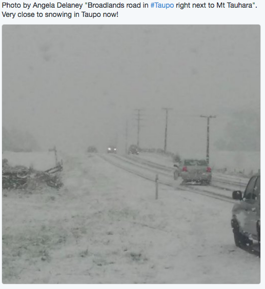
Late Saturday afternoon snow fell close to Taupo. The town was on 3.3 degrees with rain while snow fell on Mt Tauhara and nearby Broadlands Road.
 However despite night time, temperatures have actually gone up a degree making snow flurries in Taupo less likely. We can’t rule it out though – but generally Taupo is looking about 2 degrees too warm for snow to get into the town, at least at this stage.
On Friday WeatherWatch.co.nz advised motorists that highways connecting Hawke’s Bay to other regions may be shut off by snow, ice, gales, rain and possible slips – now two of the three State Highways out of Hawke’s Bay are closed due to the adverse weather:
ROAD CLOSURES: (as of 7:30pm Saturday)
- The Napier-Taupo Highway (SH5) is closed due to snow.
- The Napier-Wairoa Highway (SH2) is closed due to flooding.
- The Desert Road (SH1) is closed due to snow.
- Please visit the NZTA website for the latest roading information – we do not monitor all highways.
Below is the 12 noon rain map for Saturday – and this is pretty much how most of Saturday AND Sunday looks.
This is a significant and rare snow event for the region.

– Image / 12 noon Saturday rain and wind map for the North Island looks similar to Sunday AM too – via Weathermap
– WeatherWatch.co.nz
Comments
Before you add a new comment, take note this story was published on 6 Aug 2016.
Latest Video

(VIDEO) NZ 7 Day: Variety in the weather, but Southern Ocean storms waking up
Low pressure moves in to NZ from the Tasman Sea this weekend and completely falls apart – bringing downpours and…
Related Articles
(VIDEO) NZ 7 Day: Variety in the weather, but Southern Ocean storms waking up
Low pressure moves in to NZ from the Tasman Sea this weekend and completely falls apart – bringing downpours and…

VIDEO: ClimateWatch: July is the month of BIG lows, BIG highs
This month around New Zealand, Australia and the region we see big highs and big lows – bringing decent stretches…

VIDEO: Severe weather risks for NZ as low moves in
Programming Note: Apologies but we have no video on Thursday – back again on Friday! – A storm in the…


Add new comment
Guest on 6/08/2016 8:18am
It is strange. Temperature is 4 degrees in Te Pohue (350m), with heavy snow falling and settling. I thought it would melt?
Reply
WW Forecast Team on 6/08/2016 8:26am
The air above you must be extra chilled (which is very likely) – and the surfaces must be cooler than 4 degrees as well, so possible it can settle but certainly 4 degrees is starting to get to the warmer side of settling 🙂
– WW
Reply
peter on 6/08/2016 8:08am
There was definitely snow very close to Taupo this afternoon. The bypass was high enough to get flakes. The Napier road was a white out basically on all higher ground above the Z service station. Also plenty of snow about 20km north of Taupo along SH1.
Reply
Ian Cooper on 6/08/2016 3:59am
It is interesting if you take the date that is halfway between the Winter Solstice in June and the Spring Equinox in September you get today (August 6th)! It isn’t surprising then that we are getting extreme winter weather on mid-winter’s day. Those of a Celtic or Chinese background often believe that spring in the southern hemisphere would start now on what is known as a ‘cross quarter’ day. I think the Babylonian/Greco system adopted by the Romans is more often a reflection of our seasons.
In a good year the blossoms are out at this time, lambs & calves have been popping out for weeks, but those things don’t define a season. A season is defined by what causes it, not by the symptoms such as weather and the arrival of newborn buds or babes that are tangible signs of a particular season.
There is only one cause of the seasons and that is the axial tilt of the Earth in relation to its elliptical orbit around the sun. Even that ellipticity has less of a bearing than the tilt. Without that tilt we wouldn’t have the variety in climate that we enjoy now. In stead we would have climatic zones not unlike Jupiter which has hardly any tilt at all.
So happy “Mid-Winter’s Day” everyone. Keep warm & keep safe.
Reply
Ginny on 7/08/2016 12:40pm
We are 10 km north of Te Pohue at an altitude of 460 metres yet we didn’t get any snow settling, just a huge amount of rain with some snow mixed in, rather amusing to see a snow Plough coming down the road with not a stitch in sight yet up the hill and little on both sides they are clearing huge drifts of the white stuff.. If you didn’t look up you could be forgiven for thinking that it was all make believe.
Reply