InfoGraphic: The Main Weather News Highlights across NZ: Thu, Fri, Sat
5/07/2017 7:00pm

> From the WeatherWatch archives
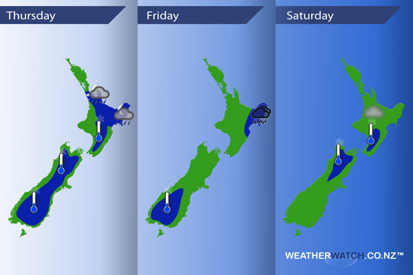
Today sees an occluded frontal zone lying over the upper North Island while an easterly quarter airflow flows over the rest of the country. The occluded front moves a little further south on Friday, easterly quarter winds for everyone else. A northwesterly airflow develops on Saturday.
Thursday
Blue – A frontal zone may bring the odd heavy shower or area of rain about Auckland from late afternoon then a little further south into Gisborne overnight.
A frosty start again for some mainly inland away from the coast. The coldest overnight lows will be about inland South Island areas. It has reached -10 degrees about Mt Cook which is the coldest reading so far.
Friday
Blue – Rain with heavy falls about East Cape / Gisborne and perhaps Hawkes Bay then easing from afternoon.
Fairly cloudy skies keep frosts away for most however the lower South Island sees quite cold temperatures around dawn, -4 degrees looks possible for some.
Saturday
Blue – A touch of frost about the upper South Island in the morning, also the lower North Island. Nothing major.
There may also be a risk of fog to start the day about the Waikato and perhaps Auckland.
– Please note, the idea behind this update is to focus on the main weather highlights, which is why not all regions are mentioned.
For specific 10 day information for your city, town, rural community or island please see the 1500 forecasts on our homepage!
– Aaron Wilkinson, WeatherWatch.co.nz
Comments
Before you add a new comment, take note this story was published on 5 Jul 2017.
Latest Video

NZ VIDEO: More lows, but a reduction in severe weather
More low pressure is coming in to New Zealand this week – but rainfall isn’t as dramatic as previous weeks,…
Related Articles
NZ VIDEO: More lows, but a reduction in severe weather
More low pressure is coming in to New Zealand this week – but rainfall isn’t as dramatic as previous weeks,…

NZ VIDEO: Westerlies, lows, showers & large dry areas
Messy westerly driven weather will affect NZ this week, bringing more wet weather to western and northern parts of the…

NZ VIDEO: Westerlies continue
Heavy rain and northerly gales are moving across NZ going into the weekend as a large low from the Tasman…


Add new comment