InfoGraphic: The Main Weather News Highlights across NZ: Mon, Tue, Wed
2/07/2017 7:00pm

> From the WeatherWatch archives
A low pressure system moves from west to east over the North Island today while a cold south to southwesterly airflow lies over the South Island, spreading over the North Island as the day moves along. A cold southwest front moves northwards over the South Island on Tuesday reaching the lower North Island late afternoon. A ridge brings some settled weather for a time on Wednesday.
Monday
Blue – A frost start this morning about the upper South Island inland.
Showers this afternoon about the upper North island could become heavy then easing by evening.
Risk of a morning fog patch about the Waikato.
White – Overnight a cold southwest change moves onto the lower South Island bringing snow flurries to 400m.
Tuesday
Blue – A tad cool to start the day in the areas marked below, no major frosts.
White – A few morning snow flurries to 400m about North Otago / South Canterbury clear then from midday further snow flurries develop about Southland and Otago down to 400m, clearing overnight. Snow amounts will not be very much but still worth keeping an eye on.
Wednesday
Blue – A frosty start to the day for many, especially the South Island where some isolated inland spots may dip into -7 to -8 degree territory.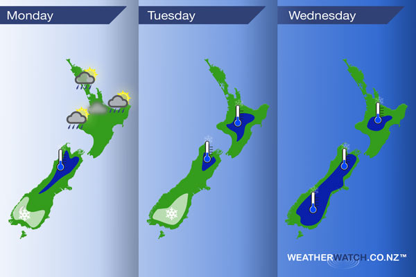
– Please note, the idea behind this update is to focus on the main weather highlights, which is why not all regions are mentioned.
For specific 10 day information for your city, town, rural community or island please see the 1500 forecasts on our homepage!
– Aaron Wilkinson, WeatherWatch.co.nz
Comments
Before you add a new comment, take note this story was published on 2 Jul 2017.
Latest Video

NZ VIDEO: More lows, but a reduction in severe weather
More low pressure is coming in to New Zealand this week – but rainfall isn’t as dramatic as previous weeks,…
Related Articles
NZ VIDEO: More lows, but a reduction in severe weather
More low pressure is coming in to New Zealand this week – but rainfall isn’t as dramatic as previous weeks,…

NZ VIDEO: Westerlies, lows, showers & large dry areas
Messy westerly driven weather will affect NZ this week, bringing more wet weather to western and northern parts of the…

NZ VIDEO: Westerlies continue
Heavy rain and northerly gales are moving across NZ going into the weekend as a large low from the Tasman…


Add new comment